San Antonio geodata
San Antonio (State of Mexico) is a populated place; located in Mexico in America/Mexico_City (GMT-6) time zone. With population of 565 people, there are 15122 cities with bigger population in this country. Compared to other cities in Mexico, 55.9% of cities are located further ↑North; 57.1% of cities are located further →East and 94.8% of cities have lower elevation than San Antonio. Note1


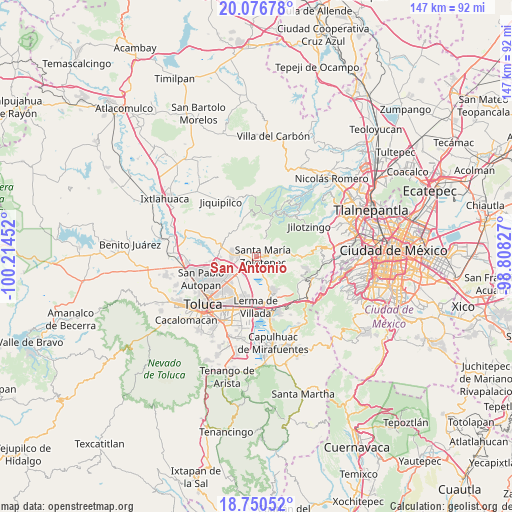
San Antonio GPS coordinates[2]
19° 24' 54" North, 99° 30' 41.004" West
| Map corner | latitude | longitude |
|---|---|---|
| Upper-left | 20.07678°, | -100.21452° |
| Center: | 19.415°, | -99.51139° |
| Lower-right: | 18.75052°, | -98.80827° |
| Map W x H: | 147.5×147.5 km | = 91.7×91.7mi |
| max Lat: | 32.7° ⇑55.9% North |
| San Antonio: | 19.415° |
| min Lat: | ⇓44.1% South 14.53588° |
| min Long | San Antonio | max Long |
| -117.105° | -99.51139° | -86.73105° |
| W 42.9%⇐ | ⇒57.1% E |
Elevation
Elevation of San Antonio is 2591 m = 8501 ft, and this is 1337.3 m = 4387 ft above average elevation for this country.
| Max E: |
3497 m = 11473 ft | 5.2% |
| San Antonio | 2591 m 8501 ft | |
| Avg. | 1253.7 m = 4113 ft | |
Min E: |
-1 m = -3 ft | 94.8% |
See also: Mexico elevation on elevation.city.
Geographical zone
San Antonio is located in North Torrid zone (between Equator and Tropic of Cancer). Distance of this Northern Tropic circle is 447.2 km =277.9 mi to North.| Distance of | km | miles | from San Antonio |
|---|---|---|---|
| North Pole | 7848.3 | 4876.7 | to North |
| Arctic Circle | 5242.4 | 3257.5 | to North |
| Tropic Cancer | 447.2 | 277.9 | to North |
| Equator | 2158.7 | 1341.4 | to South |


Nearby cities:
15 places around San Antonio: (largest is in red/bold)
• Barrio de San Juan
2.7 km =1.7 mi,  268°
268°
• Colonia Adolfo López Mateos
1.7 km =1.1 mi,  263°
263°
• Colonia Emiliano Zapata
3 km =1.9 mi,  208°
208°
• Colonia Reforma Tlalmimilolpan
3.8 km =2.4 mi,  141°
141°
• Ejido de Mozoquilpan
2 km =1.2 mi,  299°
299°
• La Concepción de Hidalgo
4.5 km =2.8 mi,  332°
332°
• La Herradura
3.6 km =2.2 mi,  88°
88°
• Los Laureles
4.2 km =2.6 mi,  78°
78°
• Pueblo Nuevo Tlalmimilolpan
2.7 km =1.7 mi,  158°
158°
• San Isidro las Trojes
3.6 km =2.2 mi, 304°
• San Pedro Huitzizilapan
3.6 km =2.2 mi,  106°
106°
• Santa Ana Mayorazgo
1.6 km =1 mi,  355°
355°
• Santa Catarina
2.4 km =1.5 mi,  132°
132°
• Santa María Zolotepec
1.9 km =1.2 mi, 82°
• Xonacatlán
2.1 km =1.3 mi,  237°
237°
Sources, notices
• [Note1] Compared only with cities in Mexico existing in our database
• [Src1] Map data: © OpenStreetMap contributors (CC-BY-SA)
• [Src2] Other city data from geonames.org with taken over terms of usage.
• [Src3] Geographical zone / Annual Mean Temperature by Robert A. Rohde @ Wikipedia
