Surulere geodata
Surulere (Lagos) is a seat of a second-order administrative division; located in Nigeria in Africa/Lagos (GMT+1) time zone. In our database, there are 451 cities with bigger population. Compared to other cities in Nigeria, 76.6% of cities are located further ↑North; 97.1% of cities are located further →East and 95.7% of cities have higher elevation than Surulere. Note1


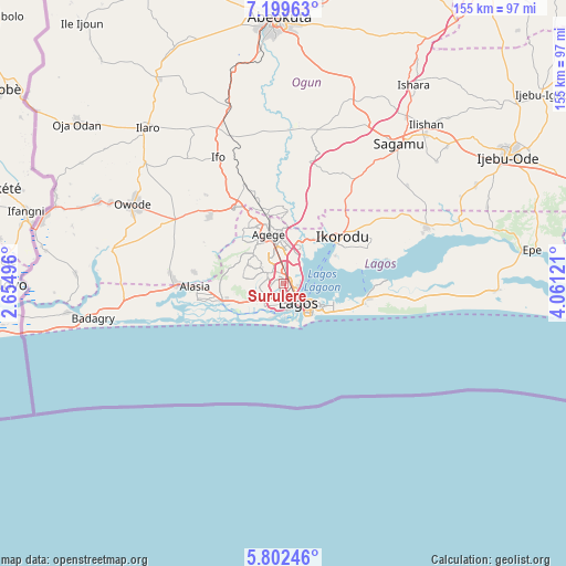
Surulere GPS coordinates[2]
6° 30' 5.508" North, 3° 21' 29.088" East
| Map corner | latitude | longitude |
|---|---|---|
| Upper-left | 7.19963°, | 2.65496° |
| Center: | 6.50153°, | 3.35808° |
| Lower-right: | 5.80246°, | 4.06121° |
| Map W x H: | 155.4×155.4 km | = 96.6×96.6mi |
| max Lat: | 13.7543° ⇑76.6% North |
| Surulere: | 6.50153° |
| min Lat: | ⇓23.4% South 4.31231° |
| min Long | Surulere | max Long |
| 2.73333° | 3.35808° | 14.46552° |
| W 2.9%⇐ | ⇒97.1% E |
Elevation
Elevation of Surulere is 10 m = 33 ft, and this is 286.5 m = 940 ft below average elevation for this country.
| Max E: |
1599 m = 5246 ft | 95.7% |
| Avg. | 296.5 m = 973 ft | |
| Surulere | 10 m = 33 ft | |
Min E: |
2 m = 7 ft | 4.3% |
See also: Nigeria elevation on elevation.city.
Geographical zone
Surulere is located in North Torrid zone (between Equator and Tropic of Cancer). Distance of Equator is 722.9 km =449.2 mi to South.| Distance of | km | miles | from Surulere |
|---|---|---|---|
| North Pole | 9284.2 | 5768.9 | to North |
| Arctic Circle | 6678.3 | 4149.7 | to North |
| Tropic Cancer | 1883 | 1170 | to North |
| Equator | 722.9 | 449.2 | to South |


Nearby cities:
15 places around Surulere: (largest is in red/bold)
• Agege
13 km =8.1 mi,  347°
347°
• Ajegunle
6.3 km =3.9 mi,  208°
208°
• Apapa
5.9 km =3.7 mi,  178°
178°
• Ebute-Metta
3 km =1.9 mi,  120°
120°
• Festac Town
9 km =5.6 mi,  246°
246°
• Ifako
16.3 km =10.1 mi, 346°
• Ikeja
10.7 km =6.6 mi, 350°
• Ikotun
11.5 km =7.1 mi,  294°
294°
• Ikoyi
10.2 km =6.3 mi, 122°
• Lagos
6.6 km =4.1 mi,  142°
142°
• Makoko
3.3 km =2.1 mi,  100°
100°
• Mushin
3 km =1.9 mi, 351°
• Ojota
9.1 km =5.7 mi,  20°
20°
• Oshodi
6.2 km =3.9 mi,  344°
344°
• Somolu
4.5 km =2.8 mi, 23°
Sources, notices
• [Note1] Compared only with cities in Nigeria existing in our database
• [Src1] Map data: © OpenStreetMap contributors (CC-BY-SA)
• [Src2] Other city data from geonames.org with taken over terms of usage.
• [Src3] Geographical zone / Annual Mean Temperature by Robert A. Rohde @ Wikipedia
