Kano geodata
Kano is a seat of a first-order administrative division; located in Nigeria in Africa/Lagos (GMT+1) time zone. With population of 3,626,068 people, there is 1 city with bigger population in this country. Compared to other cities in Nigeria, 84.2% of cities are located further ↓South; 72% of cities are located further ←West and 81.8% of cities have lower elevation than Kano. Note1


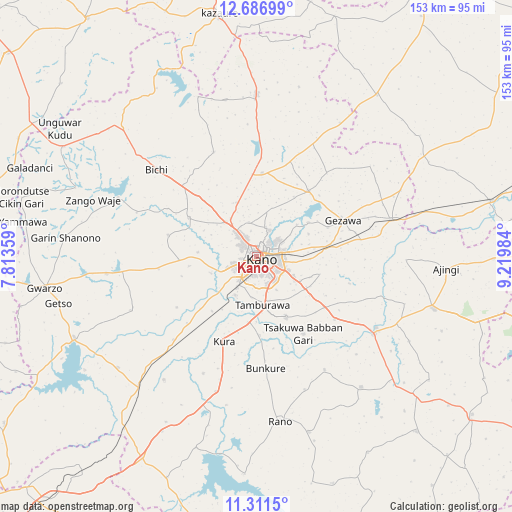
Kano GPS coordinates[2]
12° 0' 0.432" North, 8° 31' 0.192" East
| Map corner | latitude | longitude |
|---|---|---|
| Upper-left | 12.68699°, | 7.81359° |
| Center: | 12.00012°, | 8.51672° |
| Lower-right: | 11.3115°, | 9.21984° |
| Map W x H: | 152.9×152.9 km | = 95×95mi |
| max Lat: | 13.7543° ⇑15.8% North |
| Kano: | 12.00012° |
| min Lat: | ⇓84.2% South 4.31231° |
| min Long | Kano | max Long |
| 2.73333° | 8.51672° | 14.46552° |
| W 72%⇐ | ⇒28% E |
Elevation
Elevation of Kano is 484 m = 1588 ft, and this is 187.5 m = 615 ft above average elevation for this country.
| Max E: |
1599 m = 5246 ft | 18.2% |
| Kano | 484 m 1588 ft | |
| Avg. | 296.5 m = 973 ft | |
Min E: |
2 m = 7 ft | 81.8% |
See also: Kano elevation on elevation.city.
Geographical zone
Kano is located in North Torrid zone (between Equator and Tropic of Cancer). Distance of this Northern Tropic circle is 1271.6 km =790.1 mi to North.| Distance of | km | miles | from Kano |
|---|---|---|---|
| North Pole | 8672.8 | 5389 | to North |
| Arctic Circle | 6066.9 | 3769.8 | to North |
| Tropic Cancer | 1271.6 | 790.1 | to North |
| Equator | 1334.3 | 829.1 | to South |


Nearby cities:
15 places around Kano: (largest is in red/bold)
• Bichi
39.7 km =24.7 mi,  310°
310°
• Bunkure
33.6 km =20.9 mi,  175°
175°
• Dawakin Kudu
20.1 km =12.5 mi,  154°
154°
• Dawakin Tofa
23.4 km =14.5 mi,  299°
299°
• Garun Malam
38.4 km =23.9 mi,  204°
204°
• Gezawa
27.8 km =17.3 mi,  66°
66°
• Kabo
41 km =25.5 mi,  246°
246°
• Kumbotso
12.3 km =7.6 mi,  186°
186°
• Kura
27.2 km =16.9 mi, 201°
• Madobi
35.1 km =21.8 mi,  225°
225°
• Minjibir
25 km =15.5 mi,  37°
37°
• Rimin Gado
29.5 km =18.3 mi,  262°
262°
• Tofa
27.3 km =17 mi,  283°
283°
• Ungogo
10.4 km =6.5 mi,  347°
347°
• Warawa
25 km =15.5 mi,  126°
126°
Sources, notices
• [Note1] Compared only with cities in Nigeria existing in our database
• [Src1] Map data: © OpenStreetMap contributors (CC-BY-SA)
• [Src2] Other city data from geonames.org with taken over terms of usage.
• [Src3] Geographical zone / Annual Mean Temperature by Robert A. Rohde @ Wikipedia
