Vilt geodata
Vilt (Limburg) is a populated place; located in Netherlands in Europe/Amsterdam (GMT+2) time zone. With population of 900 people, there are 1462 cities with bigger population in this country. Compared to other cities in Netherlands, 98% of cities are located further ↑North; 58% of cities are located further ←West and 98.2% of cities have lower elevation than Vilt. Note1


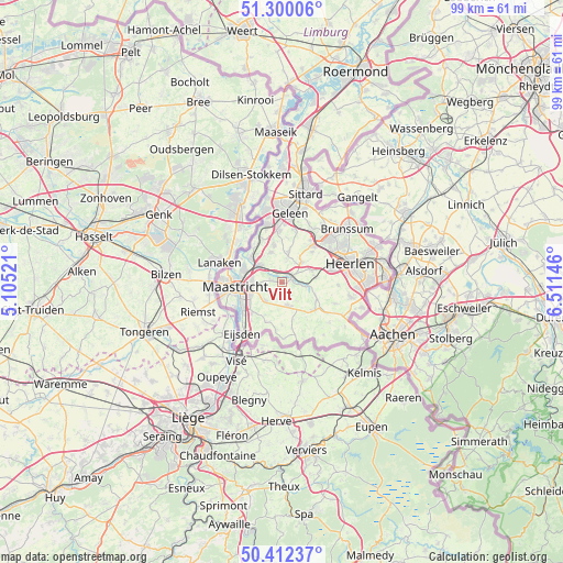
Vilt GPS coordinates[2]
50° 51' 29.988" North, 5° 48' 29.988" East
| Map corner | latitude | longitude |
|---|---|---|
| Upper-left | 51.30006°, | 5.10521° |
| Center: | 50.85833°, | 5.80833° |
| Lower-right: | 50.41237°, | 6.51146° |
| Map W x H: | 98.7×98.7 km | = 61.3×61.3mi |
| max Lat: | 53.48025° ⇑98% North |
| Vilt: | 50.85833° |
| min Lat: | ⇓2% South 50.76917° |
| min Long | Vilt | max Long |
| 3.38611° | 5.80833° | 7.16528° |
| W 58%⇐ | ⇒42% E |
Elevation
Elevation of Vilt is 131 m = 430 ft, and this is 116 m = 381 ft above average elevation for this country.
| Max E: |
203 m = 666 ft | 1.8% |
| Vilt | 131 m 430 ft | |
| Avg. | 15 m = 49 ft | |
Min E: |
-6 m = -20 ft | 98.2% |
See also: Netherlands elevation on elevation.city.
Geographical zone
Vilt is located in North temperate zone (between Tropic of Cancer and the Arctic Circle). Distance of this North polar circle is 1746.3 km =1085.1 mi to North.| Distance of | km | miles | from Vilt |
|---|---|---|---|
| North Pole | 4352.1 | 2704.3 | to North |
| Arctic Circle | 1746.3 | 1085.1 | to North |
| Tropic Cancer | 3049 | 1894.6 | to South |
| Equator | 5654.9 | 3513.8 | to South |


Nearby cities:
15 places around Vilt: (largest is in red/bold)
• Amby
5.4 km =3.4 mi,  274°
274°
• Arensgenhout
4 km =2.5 mi,  33°
33°
• Berg
1.8 km =1.1 mi,  281°
281°
• Broekhem
1.7 km =1.1 mi, 31°
• Houthem
1.9 km =1.2 mi,  325°
325°
• Hulsberg
4.8 km =3 mi,  44°
44°
• Klimmen
5.4 km =3.4 mi,  68°
68°
• Margraten
4.3 km =2.7 mi,  168°
168°
• Meerssen
5.2 km =3.2 mi,  308°
308°
• Rothem
5.3 km =3.3 mi,  292°
292°
• Scharn
5.3 km =3.3 mi,  260°
260°
• Schin op Geul
4.3 km =2.7 mi,  96°
96°
• Sibbe
2 km =1.2 mi,  141°
141°
• Sint Gerlach
1.8 km =1.1 mi,  322°
322°
• Valkenburg
1.8 km =1.1 mi, 65°
Sources, notices
• [Note1] Compared only with cities in Netherlands existing in our database
• [Src1] Map data: © OpenStreetMap contributors (CC-BY-SA)
• [Src2] Other city data from geonames.org with taken over terms of usage.
• [Src3] Geographical zone / Annual Mean Temperature by Robert A. Rohde @ Wikipedia
