Tysvær geodata
Tysvær (Rogaland) is a populated place; located in Norway in Europe/Oslo (GMT+2) time zone. With population of 1,077 people, there are 300 cities with bigger population in this country. Compared to other cities in Norway, 82.6% of cities are located further ↑North; 90.2% of cities are located further →East and 70.6% of cities have higher elevation than Tysvær. Note1


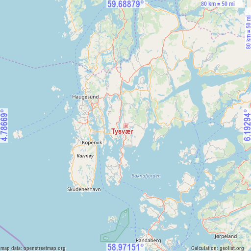
Tysvær GPS coordinates[2]
59° 19' 55.344" North, 5° 29' 23.316" East
| Map corner | latitude | longitude |
|---|---|---|
| Upper-left | 59.68879°, | 4.78669° |
| Center: | 59.33204°, | 5.48981° |
| Lower-right: | 58.97151°, | 6.19294° |
| Map W x H: | 79.8×79.8 km | = 49.6×49.6mi |
| max Lat: | 71.04137° ⇑82.6% North |
| Tysvær: | 59.33204° |
| min Lat: | ⇓17.4% South 58.0274° |
| min Long | Tysvær | max Long |
| 4.71485° | 5.48981° | 31.11066° |
| W 9.8%⇐ | ⇒90.2% E |
Elevation
Elevation of Tysvær is 18 m = 59 ft, and this is 86.2 m = 283 ft below average elevation for this country.
| Max E: |
897 m = 2943 ft | 70.6% |
| Avg. | 104.2 m = 342 ft | |
| Tysvær | 18 m = 59 ft | |
Min E: |
1 m = 3 ft | 29.4% |
See also: Norway elevation on elevation.city.
Geographical zone
Tysvær is located in North temperate zone (between Tropic of Cancer and the Arctic Circle). Distance of this North polar circle is 804.1 km =499.6 mi to North.| Distance of | km | miles | from Tysvær |
|---|---|---|---|
| North Pole | 3410 | 2118.9 | to North |
| Arctic Circle | 804.1 | 499.6 | to North |
| Tropic Cancer | 3991.2 | 2480 | to South |
| Equator | 6597.1 | 4099.2 | to South |


Nearby cities:
15 places around Tysvær: (largest is in red/bold)
• Aksdal
10.5 km =6.5 mi,  346°
346°
• Bokn
11.7 km =7.3 mi,  195°
195°
• Eike
10.3 km =6.4 mi,  315°
315°
• Haugesund
15.5 km =9.6 mi,  305°
305°
• Judaberg
28.3 km =17.6 mi,  129°
129°
• Kopervik
11.7 km =7.3 mi,  242°
242°
• Skjold
19.8 km =12.3 mi,  16°
16°
• Skudeneshavn
24.3 km =15.1 mi,  212°
212°
• Sveio
24.6 km =15.3 mi,  341°
341°
• Sæveland
18 km =11.2 mi,  246°
246°
• Vedavågen
15.9 km =9.9 mi, 254°
• Vikevåg
28.6 km =17.8 mi,  155°
155°
• Visnes
14.5 km =9 mi,  280°
280°
• Vormedal
10 km =6.2 mi,  285°
285°
• Åkrehamn
18.9 km =11.7 mi, 245°
Sources, notices
• [Note1] Compared only with cities in Norway existing in our database
• [Src1] Map data: © OpenStreetMap contributors (CC-BY-SA)
• [Src2] Other city data from geonames.org with taken over terms of usage.
• [Src3] Geographical zone / Annual Mean Temperature by Robert A. Rohde @ Wikipedia
