Papetoai geodata
Papetoai (Îles du Vent) is a populated place; located in French Polynesia in Pacific/Tahiti (GMT-10) time zone. With population of 1,964 people, there are 23 cities with bigger population in this country. Compared to other cities in French Polynesia, 74.4% of cities are located further ↓South; 74.4% of cities are located further →East and 61.5% of cities have lower elevation than Papetoai. Note1


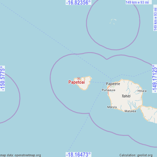
Papetoai GPS coordinates[2]
17° 29' 43.368" South, 149° 52' 27.732" West
| Map corner | latitude | longitude |
|---|---|---|
| Upper-left | -16.82356°, | -150.5775° |
| Center: | -17.49538°, | -149.87437° |
| Lower-right: | -18.16473°, | -149.17125° |
| Map W x H: | 149.1×149.1 km | = 92.6×92.6mi |
| max Lat: | -8.91093° ⇑25.6% North |
| Papetoai: | -17.49538° |
| min Lat: | ⇓74.4% South -23.34722° |
| min Long | Papetoai | max Long |
| -151.74913° | -149.87437° | -134.96858° |
| W 25.6%⇐ | ⇒74.4% E |
Elevation
Elevation of Papetoai is 14 m = 46 ft, and this is 8.6 m = 28 ft below average elevation for this country.
| Max E: |
245 m = 804 ft | 38.5% |
| Avg. | 22.6 m = 74 ft | |
| Papetoai | 14 m = 46 ft | |
Min E: |
1 m = 3 ft | 61.5% |
See also: French Polynesia elevation on elevation.city.
Geographical zone
Papetoai is located in South Torrid zone (between Equator and Tropic of Capricorn). Distance of this Southern Tropic circle is 660.6 km =410.5 mi to South.| Distance of | km | miles | from Papetoai |
|---|---|---|---|
| Equator | 1945.3 | 1208.8 | to North |
| Tropic Capricorn | 660.6 | 410.5 | to South |
| Antarctic Circle | 5455.9 | 3390.1 | to South |
| South Pole | 8061.8 | 5009.4 | to South |


Nearby cities:
15 places around Papetoai: (largest is in red/bold)
• Afareaitu
11.4 km =7.1 mi,  122°
122°
• Arue
39.8 km =24.7 mi,  93°
93°
• Faaa
29.7 km =18.5 mi,  101°
101°
• Haapiti
7.6 km =4.7 mi,  175°
175°
• Mahaena
59.7 km =37.1 mi, 97°
• Mahina
40.9 km =25.4 mi, 91°
• Otutara
57.7 km =35.9 mi, 122°
• Paea
37.3 km =23.2 mi, 124°
• Paopao
6.1 km =3.8 mi,  114°
114°
• Papao
44.5 km =27.7 mi,  129°
129°
• Papeete
33 km =20.5 mi, 98°
• Pirae
36.2 km =22.5 mi, 93°
• Punaauia
32.9 km =20.4 mi, 117°
• Teavaro
11.4 km =7.1 mi, 92°
• Tiarei
57.5 km =35.7 mi, 94°
Sources, notices
• [Note1] Compared only with cities in French Polynesia existing in our database
• [Src1] Map data: © OpenStreetMap contributors (CC-BY-SA)
• [Src2] Other city data from geonames.org with taken over terms of usage.
• [Src3] Geographical zone / Annual Mean Temperature by Robert A. Rohde @ Wikipedia
