Union geodata
Union (Western Visayas) is a populated place; located in Philippines in Asia/Manila (GMT+8) time zone. With population of 2,285 people, there are 3712 cities with bigger population in this country. Compared to other cities in Philippines, 50.7% of cities are located further ↓South; 61.6% of cities are located further →East and 51.8% of cities have higher elevation than Union. Note1


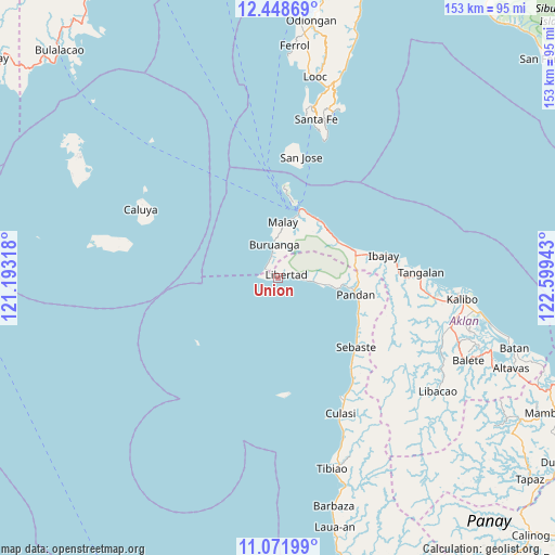
Union GPS coordinates[2]
11° 45' 40.32" North, 121° 53' 46.68" East
| Map corner | latitude | longitude |
|---|---|---|
| Upper-left | 12.44869°, | 121.19318° |
| Center: | 11.7612°, | 121.8963° |
| Lower-right: | 11.07199°, | 122.59943° |
| Map W x H: | 153.1×153.1 km | = 95.1×95.1mi |
| max Lat: | 20.78733° ⇑49.3% North |
| Union: | 11.7612° |
| min Lat: | ⇓50.7% South 4.65442° |
| min Long | Union | max Long |
| 117.04868° | 121.8963° | 126.58417° |
| W 38.4%⇐ | ⇒61.6% E |
Elevation
Elevation of Union is 22 m = 72 ft, and this is 65.9 m = 216 ft below average elevation for this country.
| Max E: |
2262 m = 7421 ft | 51.8% |
| Avg. | 87.9 m = 288 ft | |
| Union | 22 m = 72 ft | |
Min E: |
-2 m = -7 ft | 48.2% |
See also: Philippines elevation on elevation.city.
Geographical zone
Union is located in North Torrid zone (between Equator and Tropic of Cancer). Distance of this Northern Tropic circle is 1298.2 km =806.7 mi to North.| Distance of | km | miles | from Union |
|---|---|---|---|
| North Pole | 8699.3 | 5405.5 | to North |
| Arctic Circle | 6093.5 | 3786.3 | to North |
| Tropic Cancer | 1298.2 | 806.7 | to North |
| Equator | 1307.7 | 812.6 | to South |


Nearby cities:
15 places around Union: (largest is in red/bold)
• Aquino
24.1 km =15 mi,  73°
73°
• Balabag
23.3 km =14.5 mi,  6°
6°
• Buruanga
9.3 km =5.8 mi,  354°
354°
• Caticlan
20.4 km =12.7 mi,  19°
19°
• Gibong
19.3 km =12 mi,  53°
53°
• Libertad
2.6 km =1.6 mi, 69°
• Malabonot
23.2 km =14.4 mi, 6°
• Malay
15.5 km =9.6 mi, 5°
• Manoc-Manoc
20.7 km =12.9 mi, 14°
• Nabas
22.2 km =13.8 mi, 69°
• Pandan
22.1 km =13.7 mi,  102°
102°
• Pandan
22.3 km =13.9 mi,  94°
94°
• Patria
13.4 km =8.3 mi, 100°
• Unidos
19.8 km =12.3 mi,  35°
35°
• Yapak
21.4 km =13.3 mi, 10°
Sources, notices
• [Note1] Compared only with cities in Philippines existing in our database
• [Src1] Map data: © OpenStreetMap contributors (CC-BY-SA)
• [Src2] Other city data from geonames.org with taken over terms of usage.
• [Src3] Geographical zone / Annual Mean Temperature by Robert A. Rohde @ Wikipedia
