Radziechowy geodata
Radziechowy (Silesia) is a populated place; located in Poland in Europe/Warsaw (GMT+2) time zone. With population of 4,541 people, there are 725 cities with bigger population in this country. Compared to other cities in Poland, 95.8% of cities are located further ↑North; 57.6% of cities are located further →East and 95.8% of cities have lower elevation than Radziechowy. Note1


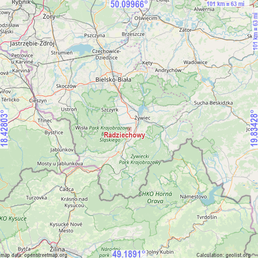
Radziechowy GPS coordinates[2]
49° 38' 47.436" North, 19° 7' 52.14" East
| Map corner | latitude | longitude |
|---|---|---|
| Upper-left | 50.09966°, | 18.42803° |
| Center: | 49.64651°, | 19.13115° |
| Lower-right: | 49.1891°, | 19.83428° |
| Map W x H: | 101.2×101.2 km | = 62.9×62.9mi |
| max Lat: | 54.83135° ⇑95.8% North |
| Radziechowy: | 49.64651° |
| min Lat: | ⇓4.2% South 49.21328° |
| min Long | Radziechowy | max Long |
| 14.20249° | 19.13115° | 24.03723° |
| W 42.4%⇐ | ⇒57.6% E |
Elevation
Elevation of Radziechowy is 437 m = 1434 ft, and this is 245.6 m = 806 ft above average elevation for this country.
| Max E: |
974 m = 3196 ft | 4.2% |
| Radziechowy | 437 m 1434 ft | |
| Avg. | 191.4 m = 628 ft | |
Min E: |
-3 m = -10 ft | 95.8% |
See also: Poland elevation on elevation.city.
Geographical zone
Radziechowy is located in North temperate zone (between Tropic of Cancer and the Arctic Circle). Distance of this North polar circle is 1881 km =1168.8 mi to North.| Distance of | km | miles | from Radziechowy |
|---|---|---|---|
| North Pole | 4486.9 | 2788 | to North |
| Arctic Circle | 1881 | 1168.8 | to North |
| Tropic Cancer | 2914.3 | 1810.9 | to South |
| Equator | 5520.2 | 3430.1 | to South |


Nearby cities:
15 places around Radziechowy: (largest is in red/bold)
• Bystra
5 km =3.1 mi,  125°
125°
• Cisiec
6.3 km =3.9 mi,  197°
197°
• Cięcina
5 km =3.1 mi,  171°
171°
• Godziszka
8.4 km =5.2 mi,  331°
331°
• Juszczyna
6.7 km =4.2 mi,  106°
106°
• Leśna
2.7 km =1.7 mi,  354°
354°
• Lipowa
4.2 km =2.6 mi,  320°
320°
• Pietrzykowice
5.9 km =3.7 mi,  20°
20°
• Przybędza
1.8 km =1.1 mi,  193°
193°
• Trzebinia
6.6 km =4.1 mi,  86°
86°
• Wieprz
3.5 km =2.2 mi, 88°
• Węgierska Górka
4.4 km =2.7 mi, 193°
• Zarzecze
8.7 km =5.4 mi, 21°
• Żabnica
7.5 km =4.7 mi, 165°
• Żywiec
6.2 km =3.9 mi,  45°
45°
Sources, notices
• [Note1] Compared only with cities in Poland existing in our database
• [Src1] Map data: © OpenStreetMap contributors (CC-BY-SA)
• [Src2] Other city data from geonames.org with taken over terms of usage.
• [Src3] Geographical zone / Annual Mean Temperature by Robert A. Rohde @ Wikipedia
