Ulieș geodata
Ulieș (Mureş) is a populated place; located in Romania in Europe/Bucharest (GMT+3) time zone. With population of 552 people, there are 6570 cities with bigger population in this country. Compared to other cities in Romania, 72.5% of cities are located further ↓South; 63.1% of cities are located further →East and 77.7% of cities have lower elevation than Ulieș. Note1


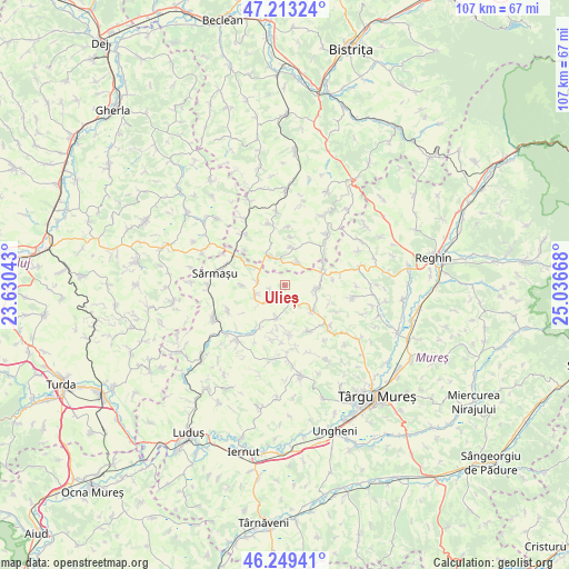
Ulieș GPS coordinates[2]
46° 44' 0.528" North, 24° 20' 0.78" East
| Map corner | latitude | longitude |
|---|---|---|
| Upper-left | 47.21324°, | 23.63043° |
| Center: | 46.73348°, | 24.33355° |
| Lower-right: | 46.24941°, | 25.03668° |
| Map W x H: | 107.2×107.2 km | = 66.6×66.6mi |
| max Lat: | 48.23793° ⇑27.5% North |
| Ulieș: | 46.73348° |
| min Lat: | ⇓72.5% South 43.65638° |
| min Long | Ulieș | max Long |
| 20.31667° | 24.33355° | 29.65403° |
| W 36.9%⇐ | ⇒63.1% E |
Elevation
Elevation of Ulieș is 373 m = 1224 ft, and this is 118.1 m = 387 ft above average elevation for this country.
| Max E: |
1278 m = 4193 ft | 22.3% |
| Ulieș | 373 m 1224 ft | |
| Avg. | 254.9 m = 836 ft | |
Min E: |
-2 m = -7 ft | 77.7% |
See also: Romania elevation on elevation.city.
Geographical zone
Ulieș is located in North temperate zone (between Tropic of Cancer and the Arctic Circle). Distance of this North polar circle is 2204.9 km =1370.1 mi to North.| Distance of | km | miles | from Ulieș |
|---|---|---|---|
| North Pole | 4810.8 | 2989.3 | to North |
| Arctic Circle | 2204.9 | 1370.1 | to North |
| Tropic Cancer | 2590.4 | 1609.6 | to South |
| Equator | 5196.3 | 3228.8 | to South |


Nearby cities:
15 places around Ulieș: (largest is in red/bold)
• Crăiești
7.5 km =4.7 mi,  68°
68°
• Dâmbu
5.1 km =3.2 mi,  281°
281°
• Milaş
12 km =7.5 mi,  39°
39°
• Pogăceaua
6.1 km =3.8 mi,  204°
204°
• Râciu
7.5 km =4.7 mi,  137°
137°
• Răzoare
11.6 km =7.2 mi,  246°
246°
• Silivașu de Câmpie
6.1 km =3.8 mi,  335°
335°
• Sânpetru de Câmpie
5.8 km =3.6 mi, 250°
• Săbed
11.5 km =7.1 mi,  131°
131°
• Sărmășel-Gară
11.3 km =7 mi,  300°
300°
• Tușinu
8.1 km =5 mi,  269°
269°
• Urmeniş
4.5 km =2.8 mi,  34°
34°
• Visuia
11.9 km =7.4 mi,  345°
345°
• Şincai
10 km =6.2 mi,  157°
157°
• Șopteriu
7.2 km =4.5 mi,  8°
8°
Sources, notices
• [Note1] Compared only with cities in Romania existing in our database
• [Src1] Map data: © OpenStreetMap contributors (CC-BY-SA)
• [Src2] Other city data from geonames.org with taken over terms of usage.
• [Src3] Geographical zone / Annual Mean Temperature by Robert A. Rohde @ Wikipedia
