Tufeşti geodata
Tufeşti (Brăila) is a seat of a second-order administrative division; located in Romania in Europe/Bucharest (GMT+3) time zone. With population of 5,784 people, there are 584 cities with bigger population in this country. Compared to other cities in Romania, 67.8% of cities are located further ↑North; 94.5% of cities are located further ←West and 98.9% of cities have higher elevation than Tufeşti. Note1


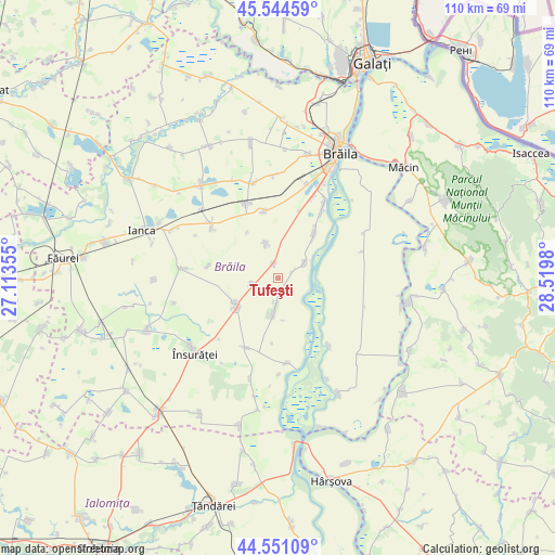
Tufeşti GPS coordinates[2]
45° 3' 0" North, 27° 49' 0.012" East
| Map corner | latitude | longitude |
|---|---|---|
| Upper-left | 45.54459°, | 27.11355° |
| Center: | 45.05°, | 27.81667° |
| Lower-right: | 44.55109°, | 28.5198° |
| Map W x H: | 110.5×110.5 km | = 68.7×68.7mi |
| max Lat: | 48.23793° ⇑67.8% North |
| Tufeşti: | 45.05° |
| min Lat: | ⇓32.2% South 43.65638° |
| min Long | Tufeşti | max Long |
| 20.31667° | 27.81667° | 29.65403° |
| W 94.5%⇐ | ⇒5.5% E |
Elevation
Elevation of Tufeşti is 12 m = 39 ft, and this is 242.9 m = 797 ft below average elevation for this country.
| Max E: |
1278 m = 4193 ft | 98.9% |
| Avg. | 254.9 m = 836 ft | |
| Tufeşti | 12 m = 39 ft | |
Min E: |
-2 m = -7 ft | 1.1% |
See also: Romania elevation on elevation.city.
Geographical zone
Tufeşti is located in North temperate zone (between Tropic of Cancer and the Arctic Circle). Distance of this North polar circle is 2392.1 km =1486.4 mi to North.| Distance of | km | miles | from Tufeşti |
|---|---|---|---|
| North Pole | 4998 | 3105.6 | to North |
| Arctic Circle | 2392.1 | 1486.4 | to North |
| Tropic Cancer | 2403.2 | 1493.3 | to South |
| Equator | 5009.1 | 3112.5 | to South |


Nearby cities:
15 places around Tufeşti: (largest is in red/bold)
• Chiscani
17.4 km =10.8 mi,  31°
31°
• Constantin Gabrielescu
14.2 km =8.8 mi,  280°
280°
• Cuza Vodă
15.4 km =9.6 mi,  205°
205°
• Gropeni
5.7 km =3.5 mi,  60°
60°
• Lanurile
5.4 km =3.4 mi,  259°
259°
• Silistraru
13.5 km =8.4 mi,  347°
347°
• Stăncuţa
16.7 km =10.4 mi,  175°
175°
• Tichileşti
9.9 km =6.2 mi,  41°
41°
• Traian
16.2 km =10.1 mi,  336°
336°
• Tudor Vladimirescu
18.6 km =11.6 mi,  355°
355°
• Unirea
7.4 km =4.6 mi,  0°
0°
• Urleasca
16.4 km =10.2 mi,  306°
306°
• Valea Cânepii
3.7 km =2.3 mi, 0°
• Viziru
9.9 km =6.2 mi,  247°
247°
• Țăcău
17 km =10.6 mi,  142°
142°
Sources, notices
• [Note1] Compared only with cities in Romania existing in our database
• [Src1] Map data: © OpenStreetMap contributors (CC-BY-SA)
• [Src2] Other city data from geonames.org with taken over terms of usage.
• [Src3] Geographical zone / Annual Mean Temperature by Robert A. Rohde @ Wikipedia
