Teiușu geodata
Teiușu (Vâlcea) is a section of populated place; located in Romania in Europe/Bucharest (GMT+3) time zone. With population of 526 people, there are 6809 cities with bigger population in this country. Compared to other cities in Romania, 65.8% of cities are located further ↑North; 65.2% of cities are located further →East and 82% of cities have lower elevation than Teiușu. Note1


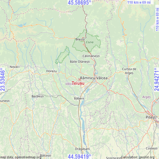
Teiușu GPS coordinates[2]
45° 5' 33.828" North, 24° 14' 22.488" East
| Map corner | latitude | longitude |
|---|---|---|
| Upper-left | 45.58695°, | 23.53646° |
| Center: | 45.09273°, | 24.23958° |
| Lower-right: | 44.59419°, | 24.94271° |
| Map W x H: | 110.4×110.4 km | = 68.6×68.6mi |
| max Lat: | 48.23793° ⇑65.8% North |
| Teiușu: | 45.09273° |
| min Lat: | ⇓34.2% South 43.65638° |
| min Long | Teiușu | max Long |
| 20.31667° | 24.23958° | 29.65403° |
| W 34.8%⇐ | ⇒65.2% E |
Elevation
Elevation of Teiușu is 412 m = 1352 ft, and this is 157.1 m = 515 ft above average elevation for this country.
| Max E: |
1278 m = 4193 ft | 18% |
| Teiușu | 412 m 1352 ft | |
| Avg. | 254.9 m = 836 ft | |
Min E: |
-2 m = -7 ft | 82% |
See also: Romania elevation on elevation.city.
Geographical zone
Teiușu is located in North temperate zone (between Tropic of Cancer and the Arctic Circle). Distance of this North polar circle is 2387.3 km =1483.4 mi to North.| Distance of | km | miles | from Teiușu |
|---|---|---|---|
| North Pole | 4993.2 | 3102.6 | to North |
| Arctic Circle | 2387.3 | 1483.4 | to North |
| Tropic Cancer | 2407.9 | 1496.2 | to South |
| Equator | 5013.8 | 3115.4 | to South |


Nearby cities:
15 places around Teiușu: (largest is in red/bold)
• Buleta
6 km =3.7 mi,  169°
169°
• Buneşti
5.2 km =3.2 mi,  301°
301°
• Bârsești
5.2 km =3.2 mi,  155°
155°
• Băile Govora
4.5 km =2.8 mi,  256°
256°
• Coasta
4.7 km =2.9 mi,  0°
0°
• Căzănești
5.3 km =3.3 mi,  134°
134°
• Gura Suhașului
4.7 km =2.9 mi,  96°
96°
• Gurișoara
2.4 km =1.5 mi,  219°
219°
• Lunca
2.3 km =1.4 mi,  77°
77°
• Ocnița
2.9 km =1.8 mi, 99°
• Prajila
5.6 km =3.5 mi, 258°
• Priporu
4.5 km =2.8 mi,  38°
38°
• Păuşeşti-Măglaşi
4.6 km =2.9 mi,  10°
10°
• Vlădeşti
5.4 km =3.4 mi,  60°
60°
• Vlăduceni
5 km =3.1 mi, 9°
Sources, notices
• [Note1] Compared only with cities in Romania existing in our database
• [Src1] Map data: © OpenStreetMap contributors (CC-BY-SA)
• [Src2] Other city data from geonames.org with taken over terms of usage.
• [Src3] Geographical zone / Annual Mean Temperature by Robert A. Rohde @ Wikipedia
