Tăure geodata
Tăure (Bistriţa-Năsăud) is a populated place; located in Romania in Europe/Bucharest (GMT+3) time zone. With population of 580 people, there are 6357 cities with bigger population in this country. Compared to other cities in Romania, 84.2% of cities are located further ↓South; 63.2% of cities are located further →East and 72.7% of cities have lower elevation than Tăure. Note1


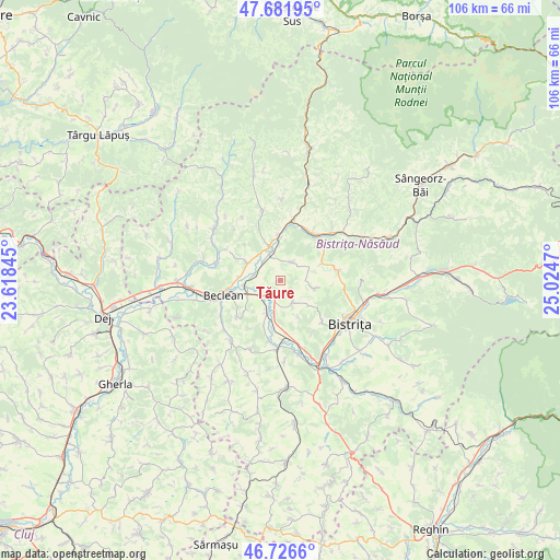
Tăure GPS coordinates[2]
47° 12' 23.148" North, 24° 19' 17.652" East
| Map corner | latitude | longitude |
|---|---|---|
| Upper-left | 47.68195°, | 23.61845° |
| Center: | 47.20643°, | 24.32157° |
| Lower-right: | 46.7266°, | 25.0247° |
| Map W x H: | 106.2×106.2 km | = 66×66mi |
| max Lat: | 48.23793° ⇑15.8% North |
| Tăure: | 47.20643° |
| min Lat: | ⇓84.2% South 43.65638° |
| min Long | Tăure | max Long |
| 20.31667° | 24.32157° | 29.65403° |
| W 36.8%⇐ | ⇒63.2% E |
Elevation
Elevation of Tăure is 338 m = 1109 ft, and this is 83.1 m = 273 ft above average elevation for this country.
| Max E: |
1278 m = 4193 ft | 27.3% |
| Tăure | 338 m 1109 ft | |
| Avg. | 254.9 m = 836 ft | |
Min E: |
-2 m = -7 ft | 72.7% |
See also: Romania elevation on elevation.city.
Geographical zone
Tăure is located in North temperate zone (between Tropic of Cancer and the Arctic Circle). Distance of this North polar circle is 2152.3 km =1337.4 mi to North.| Distance of | km | miles | from Tăure |
|---|---|---|---|
| North Pole | 4758.2 | 2956.6 | to North |
| Arctic Circle | 2152.3 | 1337.4 | to North |
| Tropic Cancer | 2642.9 | 1642.2 | to South |
| Equator | 5248.9 | 3261.5 | to South |


Nearby cities:
15 places around Tăure: (largest is in red/bold)
• Chiuza
6.2 km =3.9 mi,  298°
298°
• Cociu
6.8 km =4.2 mi,  263°
263°
• Liviu Rebreanu
10.8 km =6.7 mi,  51°
51°
• Lușca
10.3 km =6.4 mi,  38°
38°
• Mititei
8.6 km =5.3 mi,  357°
357°
• Mocod
6.5 km =4 mi,  343°
343°
• Nimigea de Jos
5.5 km =3.4 mi, 343°
• Nimigea de Sus
8.6 km =5.3 mi, 357°
• Năsăud
10.4 km =6.5 mi,  34°
34°
• Piatra
6.3 km =3.9 mi,  318°
318°
• Salva
10.6 km =6.6 mi,  11°
11°
• Săsarm
7.7 km =4.8 mi,  274°
274°
• Tărpiu
6.5 km =4 mi,  103°
103°
• Şieu-Odorhei
6.5 km =4 mi,  200°
200°
• Şintereag
3 km =1.9 mi,  212°
212°
Sources, notices
• [Note1] Compared only with cities in Romania existing in our database
• [Src1] Map data: © OpenStreetMap contributors (CC-BY-SA)
• [Src2] Other city data from geonames.org with taken over terms of usage.
• [Src3] Geographical zone / Annual Mean Temperature by Robert A. Rohde @ Wikipedia
