Sătmărel geodata
Sătmărel (Satu Mare) is a populated place; located in Romania in Europe/Bucharest (GMT+3) time zone. With population of 1,403 people, there are 3329 cities with bigger population in this country. Compared to other cities in Romania, 95.5% of cities are located further ↓South; 87.2% of cities are located further →East and 72.9% of cities have higher elevation than Sătmărel. Note1


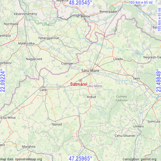
Sătmărel GPS coordinates[2]
47° 44' 4.92" North, 22° 47' 43.296" East
| Map corner | latitude | longitude |
|---|---|---|
| Upper-left | 48.20545°, | 22.09224° |
| Center: | 47.7347°, | 22.79536° |
| Lower-right: | 47.25965°, | 23.49849° |
| Map W x H: | 105.2×105.2 km | = 65.4×65.4mi |
| max Lat: | 48.23793° ⇑4.5% North |
| Sătmărel: | 47.7347° |
| min Lat: | ⇓95.5% South 43.65638° |
| min Long | Sătmărel | max Long |
| 20.31667° | 22.79536° | 29.65403° |
| W 12.8%⇐ | ⇒87.2% E |
Elevation
Elevation of Sătmărel is 117 m = 384 ft, and this is 137.9 m = 452 ft below average elevation for this country.
| Max E: |
1278 m = 4193 ft | 72.9% |
| Avg. | 254.9 m = 836 ft | |
| Sătmărel | 117 m = 384 ft | |
Min E: |
-2 m = -7 ft | 27.1% |
See also: Romania elevation on elevation.city.
Geographical zone
Sătmărel is located in North temperate zone (between Tropic of Cancer and the Arctic Circle). Distance of this North polar circle is 2093.6 km =1300.9 mi to North.| Distance of | km | miles | from Sătmărel |
|---|---|---|---|
| North Pole | 4699.5 | 2920.1 | to North |
| Arctic Circle | 2093.6 | 1300.9 | to North |
| Tropic Cancer | 2701.7 | 1678.8 | to South |
| Equator | 5307.6 | 3298 | to South |


Nearby cities:
15 places around Sătmărel: (largest is in red/bold)
• Amați
9.3 km =5.8 mi,  84°
84°
• Ambud
11.8 km =7.3 mi,  69°
69°
• Baba Novac
9.5 km =5.9 mi,  181°
181°
• Boghiș
9.5 km =5.9 mi,  286°
286°
• Dara
9.6 km =6 mi,  340°
340°
• Decebal
4.6 km =2.9 mi,  320°
320°
• Doba
5.9 km =3.7 mi,  268°
268°
• Gelu
5.8 km =3.6 mi,  187°
187°
• Mădăras
7.7 km =4.8 mi,  137°
137°
• Oar
9.2 km =5.7 mi,  328°
328°
• Pișcari
10.2 km =6.3 mi,  207°
207°
• Păuleşti
10.6 km =6.6 mi,  59°
59°
• Satu Mare
8.8 km =5.5 mi,  34°
34°
• Terebeşti
8.2 km =5.1 mi,  225°
225°
• Vetiş
7.6 km =4.7 mi, 343°
Sources, notices
• [Note1] Compared only with cities in Romania existing in our database
• [Src1] Map data: © OpenStreetMap contributors (CC-BY-SA)
• [Src2] Other city data from geonames.org with taken over terms of usage.
• [Src3] Geographical zone / Annual Mean Temperature by Robert A. Rohde @ Wikipedia
