Sarichioi geodata
Sarichioi (Tulcea) is a seat of a second-order administrative division; located in Romania in Europe/Bucharest (GMT+3) time zone. With population of 7,483 people, there are 357 cities with bigger population in this country. Compared to other cities in Romania, 71.7% of cities are located further ↑North; 99.7% of cities are located further ←West and 95% of cities have higher elevation than Sarichioi. Note1


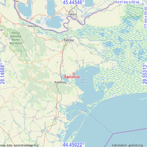
Sarichioi GPS coordinates[2]
44° 57' 0" North, 28° 51' 0" East
| Map corner | latitude | longitude |
|---|---|---|
| Upper-left | 45.44546°, | 28.14688° |
| Center: | 44.95°, | 28.85° |
| Lower-right: | 44.45022°, | 29.55313° |
| Map W x H: | 110.7×110.7 km | = 68.8×68.8mi |
| max Lat: | 48.23793° ⇑71.7% North |
| Sarichioi: | 44.95° |
| min Lat: | ⇓28.3% South 43.65638° |
| min Long | Sarichioi | max Long |
| 20.31667° | 28.85° | 29.65403° |
| W 99.7%⇐ | ⇒0.3% E |
Elevation
Elevation of Sarichioi is 35 m = 115 ft, and this is 219.9 m = 721 ft below average elevation for this country.
| Max E: |
1278 m = 4193 ft | 95% |
| Avg. | 254.9 m = 836 ft | |
| Sarichioi | 35 m = 115 ft | |
Min E: |
-2 m = -7 ft | 5% |
See also: Romania elevation on elevation.city.
Geographical zone
Sarichioi is located in North temperate zone (between Tropic of Cancer and the Arctic Circle). Distance of this Northern Tropic circle is 2392.1 km =1486.4 mi to South.| Distance of | km | miles | from Sarichioi |
|---|---|---|---|
| North Pole | 5009.1 | 3112.5 | to North |
| Arctic Circle | 2403.2 | 1493.3 | to North |
| Tropic Cancer | 2392.1 | 1486.4 | to South |
| Equator | 4998 | 3105.6 | to South |


Nearby cities:
15 places around Sarichioi: (largest is in red/bold)
• Agighiol
9.5 km =5.9 mi,  12°
12°
• Babadag
11.9 km =7.4 mi,  242°
242°
• Enisala
8.2 km =5.1 mi,  197°
197°
• Iazurile
10.8 km =6.7 mi,  42°
42°
• Lăstuni
14.8 km =9.2 mi,  305°
305°
• Mihai Bravu
15.7 km =9.8 mi,  270°
270°
• Mihail Kogălniceanu
13 km =8.1 mi,  315°
315°
• Rândunica
9.6 km =6 mi, 305°
• Sabangia
3.9 km =2.4 mi, 42°
• Sarinasuf
18.1 km =11.2 mi,  68°
68°
• Satu Nou
13.1 km =8.1 mi, 273°
• Turda
18 km =11.2 mi,  278°
278°
• Valea Nucarilor
11.3 km =7 mi, 35°
• Visterna
11.8 km =7.3 mi,  211°
211°
• Zebil
6.4 km =4 mi, 266°
Sources, notices
• [Note1] Compared only with cities in Romania existing in our database
• [Src1] Map data: © OpenStreetMap contributors (CC-BY-SA)
• [Src2] Other city data from geonames.org with taken over terms of usage.
• [Src3] Geographical zone / Annual Mean Temperature by Robert A. Rohde @ Wikipedia
