Sărata geodata
Sărata (Dolj) is a populated place; located in Romania in Europe/Bucharest (GMT+3) time zone. With population of 2,139 people, there are 2478 cities with bigger population in this country. Compared to other cities in Romania, 99.7% of cities are located further ↑North; 68.8% of cities are located further →East and 95.3% of cities have higher elevation than Sărata. Note1


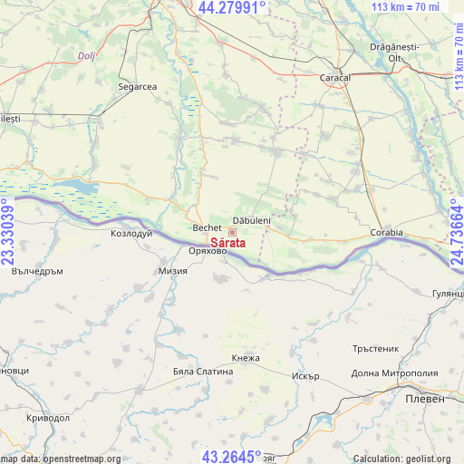
Sărata GPS coordinates[2]
43° 46' 27.696" North, 24° 2' 0.636" East
| Map corner | latitude | longitude |
|---|---|---|
| Upper-left | 44.27991°, | 23.33039° |
| Center: | 43.77436°, | 24.03351° |
| Lower-right: | 43.2645°, | 24.73664° |
| Map W x H: | 112.9×112.9 km | = 70.2×70.2mi |
| max Lat: | 48.23793° ⇑99.7% North |
| Sărata: | 43.77436° |
| min Lat: | ⇓0.3% South 43.65638° |
| min Long | Sărata | max Long |
| 20.31667° | 24.03351° | 29.65403° |
| W 31.2%⇐ | ⇒68.8% E |
Elevation
Elevation of Sărata is 34 m = 112 ft, and this is 220.9 m = 725 ft below average elevation for this country.
| Max E: |
1278 m = 4193 ft | 95.3% |
| Avg. | 254.9 m = 836 ft | |
| Sărata | 34 m = 112 ft | |
Min E: |
-2 m = -7 ft | 4.7% |
See also: Romania elevation on elevation.city.
Geographical zone
Sărata is located in North temperate zone (between Tropic of Cancer and the Arctic Circle). Distance of this Northern Tropic circle is 2261.3 km =1405.1 mi to South.| Distance of | km | miles | from Sărata |
|---|---|---|---|
| North Pole | 5139.8 | 3193.7 | to North |
| Arctic Circle | 2533.9 | 1574.5 | to North |
| Tropic Cancer | 2261.3 | 1405.1 | to South |
| Equator | 4867.3 | 3024.4 | to South |


Nearby cities:
15 places around Sărata: (largest is in red/bold)
• Bechet
6.2 km =3.9 mi,  277°
277°
• Comoșteni
17.6 km =10.9 mi,  309°
309°
• Călăraşi
3.1 km =1.9 mi,  24°
24°
• Dăbuleni
4.9 km =3 mi,  54°
54°
• Grojdibodu
18.9 km =11.7 mi,  98°
98°
• Hotaru
17.6 km =10.9 mi, 97°
• Ianca
12.1 km =7.5 mi,  85°
85°
• Lișteava
11.3 km =7 mi, 306°
• Ocolna
14.2 km =8.8 mi,  34°
34°
• Ostroveni
11.1 km =6.9 mi, 284°
• Piscu Sadovei
13.8 km =8.6 mi,  325°
325°
• Potelu
13.8 km =8.6 mi, 93°
• Sadova
15.5 km =9.6 mi, 334°
• Zăval
17.4 km =10.8 mi,  297°
297°
• Ştefan cel Mare
15.5 km =9.6 mi,  74°
74°
Sources, notices
• [Note1] Compared only with cities in Romania existing in our database
• [Src1] Map data: © OpenStreetMap contributors (CC-BY-SA)
• [Src2] Other city data from geonames.org with taken over terms of usage.
• [Src3] Geographical zone / Annual Mean Temperature by Robert A. Rohde @ Wikipedia
