Râureni geodata
Râureni (Vâlcea) is a populated place; located in Romania in Europe/Bucharest (GMT+3) time zone. With population of 681 people, there are 5684 cities with bigger population in this country. Compared to other cities in Romania, 67.4% of cities are located further ↑North; 63.2% of cities are located further →East and 52.8% of cities have lower elevation than Râureni. Note1


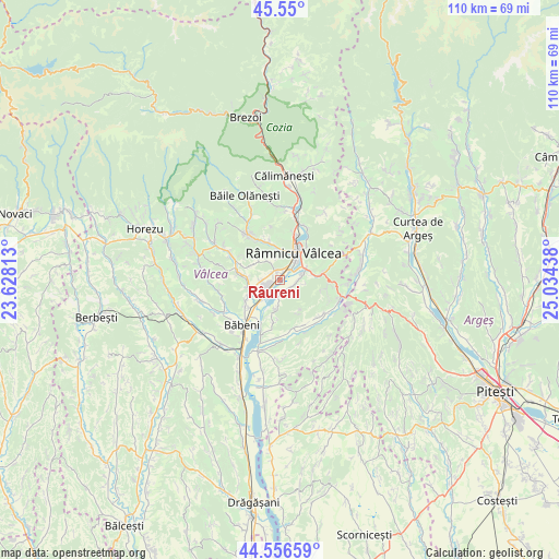
Râureni GPS coordinates[2]
45° 3' 19.62" North, 24° 19' 52.5" East
| Map corner | latitude | longitude |
|---|---|---|
| Upper-left | 45.55°, | 23.62813° |
| Center: | 45.05545°, | 24.33125° |
| Lower-right: | 44.55659°, | 25.03438° |
| Map W x H: | 110.5×110.5 km | = 68.7×68.7mi |
| max Lat: | 48.23793° ⇑67.4% North |
| Râureni: | 45.05545° |
| min Lat: | ⇓32.6% South 43.65638° |
| min Long | Râureni | max Long |
| 20.31667° | 24.33125° | 29.65403° |
| W 36.8%⇐ | ⇒63.2% E |
Elevation
Elevation of Râureni is 226 m = 741 ft, and this is 28.9 m = 95 ft below average elevation for this country.
| Max E: |
1278 m = 4193 ft | 47.2% |
| Avg. | 254.9 m = 836 ft | |
| Râureni | 226 m = 741 ft | |
Min E: |
-2 m = -7 ft | 52.8% |
See also: Romania elevation on elevation.city.
Geographical zone
Râureni is located in North temperate zone (between Tropic of Cancer and the Arctic Circle). Distance of this North polar circle is 2391.5 km =1486 mi to North.| Distance of | km | miles | from Râureni |
|---|---|---|---|
| North Pole | 4997.4 | 3105.2 | to North |
| Arctic Circle | 2391.5 | 1486 | to North |
| Tropic Cancer | 2403.8 | 1493.7 | to South |
| Equator | 5009.7 | 3112.9 | to South |


Nearby cities:
15 places around Râureni: (largest is in red/bold)
• Barza
3.2 km =2 mi,  103°
103°
• Budeşti
4.1 km =2.5 mi, 98°
• Bârsești
2.9 km =1.8 mi,  149°
149°
• Bârsești
5.1 km =3.2 mi,  263°
263°
• Copăcelu
2.1 km =1.3 mi,  311°
311°
• Căzănești
3.4 km =2.1 mi,  276°
276°
• Gura Suhașului
4.4 km =2.7 mi,  324°
324°
• Ocnița
5.6 km =3.5 mi, 310°
• Poenari
5.3 km =3.3 mi,  2°
2°
• Racovița
5.9 km =3.7 mi,  63°
63°
• Ruda
2.8 km =1.7 mi,  177°
177°
• Râmnicu Vâlcea
5.7 km =3.5 mi,  29°
29°
• Stolniceni
2.6 km =1.6 mi,  227°
227°
• Stupărei
5.8 km =3.6 mi,  223°
223°
• Troian
2.9 km =1.8 mi, 28°
Sources, notices
• [Note1] Compared only with cities in Romania existing in our database
• [Src1] Map data: © OpenStreetMap contributors (CC-BY-SA)
• [Src2] Other city data from geonames.org with taken over terms of usage.
• [Src3] Geographical zone / Annual Mean Temperature by Robert A. Rohde @ Wikipedia
