Radovanu geodata
Radovanu (Călăraşi) is a seat of a second-order administrative division; located in Romania in Europe/Bucharest (GMT+3) time zone. With population of 5,065 people, there are 763 cities with bigger population in this country. Compared to other cities in Romania, 93.3% of cities are located further ↑North; 72.9% of cities are located further ←West and 96.2% of cities have higher elevation than Radovanu. Note1


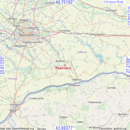
Radovanu GPS coordinates[2]
44° 12' 0" North, 26° 31' 0.012" East
| Map corner | latitude | longitude |
|---|---|---|
| Upper-left | 44.70192°, | 25.81355° |
| Center: | 44.2°, | 26.51667° |
| Lower-right: | 43.69377°, | 27.2198° |
| Map W x H: | 112.1×112.1 km | = 69.7×69.7mi |
| max Lat: | 48.23793° ⇑93.3% North |
| Radovanu: | 44.2° |
| min Lat: | ⇓6.7% South 43.65638° |
| min Long | Radovanu | max Long |
| 20.31667° | 26.51667° | 29.65403° |
| W 72.9%⇐ | ⇒27.1% E |
Elevation
Elevation of Radovanu is 28 m = 92 ft, and this is 226.9 m = 744 ft below average elevation for this country.
| Max E: |
1278 m = 4193 ft | 96.2% |
| Avg. | 254.9 m = 836 ft | |
| Radovanu | 28 m = 92 ft | |
Min E: |
-2 m = -7 ft | 3.8% |
See also: Romania elevation on elevation.city.
Geographical zone
Radovanu is located in North temperate zone (between Tropic of Cancer and the Arctic Circle). Distance of this Northern Tropic circle is 2308.7 km =1434.6 mi to South.| Distance of | km | miles | from Radovanu |
|---|---|---|---|
| North Pole | 5092.5 | 3164.3 | to North |
| Arctic Circle | 2486.6 | 1545.1 | to North |
| Tropic Cancer | 2308.7 | 1434.6 | to South |
| Equator | 4914.6 | 3053.8 | to South |


Nearby cities:
15 places around Radovanu: (largest is in red/bold)
• Aprozi
7.4 km =4.6 mi,  351°
351°
• Budeşti
5.6 km =3.5 mi,  313°
313°
• Clătești
9.2 km =5.7 mi,  133°
133°
• Crivăț
6.3 km =3.9 mi,  263°
263°
• Curcani
5.3 km =3.3 mi,  90°
90°
• Căscioarele
9 km =5.6 mi,  204°
204°
• Gruiu
8.7 km =5.4 mi,  294°
294°
• Luica
6.5 km =4 mi,  55°
55°
• Mitreni
7.6 km =4.7 mi,  119°
119°
• Nana
9.1 km =5.7 mi,  35°
35°
• Negoești
3.6 km =2.2 mi,  340°
340°
• Valea Popii
4.9 km =3 mi,  150°
150°
• Valea Roșie
9.7 km =6 mi,  104°
104°
• Valea Stânii
9.8 km =6.1 mi,  54°
54°
• Şoldanu
1.9 km =1.2 mi,  0°
0°
Sources, notices
• [Note1] Compared only with cities in Romania existing in our database
• [Src1] Map data: © OpenStreetMap contributors (CC-BY-SA)
• [Src2] Other city data from geonames.org with taken over terms of usage.
• [Src3] Geographical zone / Annual Mean Temperature by Robert A. Rohde @ Wikipedia
