Predești geodata
Predești (Vâlcea) is a populated place; located in Romania in Europe/Bucharest (GMT+3) time zone. With population of 556 people, there are 6529 cities with bigger population in this country. Compared to other cities in Romania, 70.7% of cities are located further ↑North; 62.5% of cities are located further →East and 59.2% of cities have lower elevation than Predești. Note1


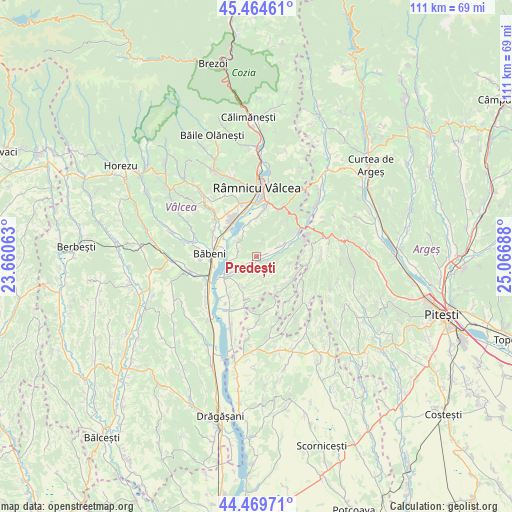
Predești GPS coordinates[2]
44° 58' 9.552" North, 24° 21' 49.5" East
| Map corner | latitude | longitude |
|---|---|---|
| Upper-left | 45.46461°, | 23.66063° |
| Center: | 44.96932°, | 24.36375° |
| Lower-right: | 44.46971°, | 25.06688° |
| Map W x H: | 110.6×110.6 km | = 68.7×68.7mi |
| max Lat: | 48.23793° ⇑70.7% North |
| Predești: | 44.96932° |
| min Lat: | ⇓29.3% South 43.65638° |
| min Long | Predești | max Long |
| 20.31667° | 24.36375° | 29.65403° |
| W 37.5%⇐ | ⇒62.5% E |
Elevation
Elevation of Predești is 259 m = 850 ft, and this is 4.1 m = 13 ft above average elevation for this country.
| Max E: |
1278 m = 4193 ft | 40.8% |
| Predești | 259 m 850 ft | |
| Avg. | 254.9 m = 836 ft | |
Min E: |
-2 m = -7 ft | 59.2% |
See also: Romania elevation on elevation.city.
Geographical zone
Predești is located in North temperate zone (between Tropic of Cancer and the Arctic Circle). Distance of this Northern Tropic circle is 2394.2 km =1487.7 mi to South.| Distance of | km | miles | from Predești |
|---|---|---|---|
| North Pole | 5006.9 | 3111.1 | to North |
| Arctic Circle | 2401.1 | 1492 | to North |
| Tropic Cancer | 2394.2 | 1487.7 | to South |
| Equator | 5000.1 | 3106.9 | to South |


Nearby cities:
15 places around Predești: (largest is in red/bold)
• Barza
8.8 km =5.5 mi,  3°
3°
• Bratia din Vale
6.4 km =4 mi,  258°
258°
• Budeşti
9.1 km =5.7 mi,  9°
9°
• Bârsești
7.2 km =4.5 mi,  351°
351°
• Cocoru
5.8 km =3.6 mi,  243°
243°
• Dealu Dănicei
9.5 km =5.9 mi,  144°
144°
• Dealu Lăunele
9.4 km =5.8 mi,  125°
125°
• Galicea
8.6 km =5.3 mi,  227°
227°
• Geamăna
5.1 km =3.2 mi,  165°
165°
• Măgura
9.7 km =6 mi,  293°
293°
• Ruda
7.2 km =4.5 mi,  340°
340°
• Stoileşti
7.9 km =4.9 mi, 168°
• Stolniceni
9 km =5.6 mi,  329°
329°
• Stupărei
8.5 km =5.3 mi,  309°
309°
• Valea Râului
5 km =3.1 mi, 227°
Sources, notices
• [Note1] Compared only with cities in Romania existing in our database
• [Src1] Map data: © OpenStreetMap contributors (CC-BY-SA)
• [Src2] Other city data from geonames.org with taken over terms of usage.
• [Src3] Geographical zone / Annual Mean Temperature by Robert A. Rohde @ Wikipedia
