Prăjani geodata
Prăjani (Prahova) is a section of populated place; located in Romania in Europe/Bucharest (GMT+3) time zone. With population of 1,344 people, there are 3438 cities with bigger population in this country. Compared to other cities in Romania, 61.5% of cities are located further ↑North; 62% of cities are located further ←West and 76.6% of cities have lower elevation than Prăjani. Note1


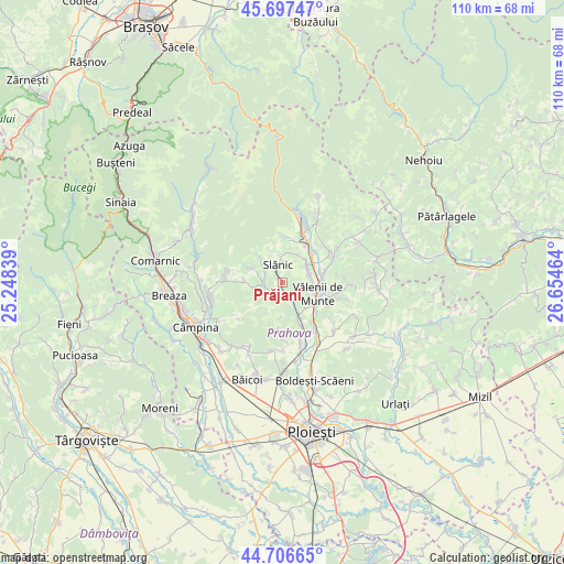
Prăjani GPS coordinates[2]
45° 12' 15.192" North, 25° 57' 5.436" East
| Map corner | latitude | longitude |
|---|---|---|
| Upper-left | 45.69747°, | 25.24839° |
| Center: | 45.20422°, | 25.95151° |
| Lower-right: | 44.70665°, | 26.65464° |
| Map W x H: | 110.2×110.2 km | = 68.5×68.5mi |
| max Lat: | 48.23793° ⇑61.5% North |
| Prăjani: | 45.20422° |
| min Lat: | ⇓38.5% South 43.65638° |
| min Long | Prăjani | max Long |
| 20.31667° | 25.95151° | 29.65403° |
| W 62%⇐ | ⇒38% E |
Elevation
Elevation of Prăjani is 365 m = 1198 ft, and this is 110.1 m = 361 ft above average elevation for this country.
| Max E: |
1278 m = 4193 ft | 23.4% |
| Prăjani | 365 m 1198 ft | |
| Avg. | 254.9 m = 836 ft | |
Min E: |
-2 m = -7 ft | 76.6% |
See also: Romania elevation on elevation.city.
Geographical zone
Prăjani is located in North temperate zone (between Tropic of Cancer and the Arctic Circle). Distance of this North polar circle is 2374.9 km =1475.7 mi to North.| Distance of | km | miles | from Prăjani |
|---|---|---|---|
| North Pole | 4980.8 | 3094.9 | to North |
| Arctic Circle | 2374.9 | 1475.7 | to North |
| Tropic Cancer | 2420.3 | 1503.9 | to South |
| Equator | 5026.2 | 3123.1 | to South |


Nearby cities:
15 places around Prăjani: (largest is in red/bold)
• Aluniş
6.7 km =4.2 mi,  265°
265°
• Bughea de Jos
6 km =3.7 mi,  116°
116°
• Groșani
4.9 km =3 mi,  356°
356°
• Livadea
2.7 km =1.7 mi,  223°
223°
• Olteni
5.4 km =3.4 mi,  63°
63°
• Ostrovu
3.8 km =2.4 mi, 268°
• Scurtești
5.3 km =3.3 mi,  314°
314°
• Slănic
5.3 km =3.3 mi,  344°
344°
• Teişani
4.1 km =2.5 mi,  37°
37°
• Trestioara
6.9 km =4.3 mi,  183°
183°
• Valea Stâlpului
5.1 km =3.2 mi,  80°
80°
• Vălenii de Munte
6.8 km =4.2 mi,  109°
109°
• Vărbilău
2.3 km =1.4 mi, 182°
• Ştefeşti
4.3 km =2.7 mi,  288°
288°
• Ștubeiu
5.5 km =3.4 mi,  70°
70°
Sources, notices
• [Note1] Compared only with cities in Romania existing in our database
• [Src1] Map data: © OpenStreetMap contributors (CC-BY-SA)
• [Src2] Other city data from geonames.org with taken over terms of usage.
• [Src3] Geographical zone / Annual Mean Temperature by Robert A. Rohde @ Wikipedia
