Poieni geodata
Poieni (Neamţ) is a populated place; located in Romania in Europe/Bucharest (GMT+3) time zone. With population of 1,231 people, there are 3675 cities with bigger population in this country. Compared to other cities in Romania, 74.9% of cities are located further ↓South; 69.8% of cities are located further ←West and 91% of cities have lower elevation than Poieni. Note1


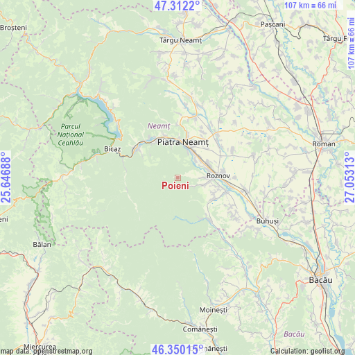
Poieni GPS coordinates[2]
46° 49' 59.988" North, 26° 21' 0" East
| Map corner | latitude | longitude |
|---|---|---|
| Upper-left | 47.3122°, | 25.64688° |
| Center: | 46.83333°, | 26.35° |
| Lower-right: | 46.35015°, | 27.05313° |
| Map W x H: | 107×107 km | = 66.5×66.5mi |
| max Lat: | 48.23793° ⇑25.1% North |
| Poieni: | 46.83333° |
| min Lat: | ⇓74.9% South 43.65638° |
| min Long | Poieni | max Long |
| 20.31667° | 26.35° | 29.65403° |
| W 69.8%⇐ | ⇒30.2% E |
Elevation
Elevation of Poieni is 528 m = 1732 ft, and this is 273.1 m = 896 ft above average elevation for this country.
| Max E: |
1278 m = 4193 ft | 9% |
| Poieni | 528 m 1732 ft | |
| Avg. | 254.9 m = 836 ft | |
Min E: |
-2 m = -7 ft | 91% |
See also: Romania elevation on elevation.city.
Geographical zone
Poieni is located in North temperate zone (between Tropic of Cancer and the Arctic Circle). Distance of this North polar circle is 2193.8 km =1363.2 mi to North.| Distance of | km | miles | from Poieni |
|---|---|---|---|
| North Pole | 4799.7 | 2982.4 | to North |
| Arctic Circle | 2193.8 | 1363.2 | to North |
| Tropic Cancer | 2601.5 | 1616.5 | to South |
| Equator | 5207.4 | 3235.7 | to South |


Nearby cities:
15 places around Poieni: (largest is in red/bold)
• Borleşti
12.6 km =7.8 mi,  126°
126°
• Brășăuți
7.5 km =4.7 mi,  61°
61°
• Chintinici
10.9 km =6.8 mi,  93°
93°
• Ciritei
11.8 km =7.3 mi,  22°
22°
• Cut
7.6 km =4.7 mi,  43°
43°
• Dumbrava Roşie
8.4 km =5.2 mi,  48°
48°
• Izvoare
12.5 km =7.8 mi, 46°
• Luminiș
8.1 km =5 mi,  105°
105°
• Mastacăn
11.5 km =7.1 mi,  115°
115°
• Negulești
5.1 km =3.2 mi, 119°
• Piatra Neamţ
9.4 km =5.8 mi,  352°
352°
• Piatra Şoimului
6.3 km =3.9 mi, 90°
• Săvineşti
9.1 km =5.7 mi,  78°
78°
• Vaduri
12.5 km =7.8 mi,  327°
327°
• Văleni
8.3 km =5.2 mi, 21°
Sources, notices
• [Note1] Compared only with cities in Romania existing in our database
• [Src1] Map data: © OpenStreetMap contributors (CC-BY-SA)
• [Src2] Other city data from geonames.org with taken over terms of usage.
• [Src3] Geographical zone / Annual Mean Temperature by Robert A. Rohde @ Wikipedia
