Pietroiu geodata
Pietroiu (Brăila) is a populated place; located in Romania in Europe/Bucharest (GMT+3) time zone. With population of 623 people, there are 6062 cities with bigger population in this country. Compared to other cities in Romania, 58.4% of cities are located further ↑North; 95.1% of cities are located further ←West and 99.5% of cities have higher elevation than Pietroiu. Note1


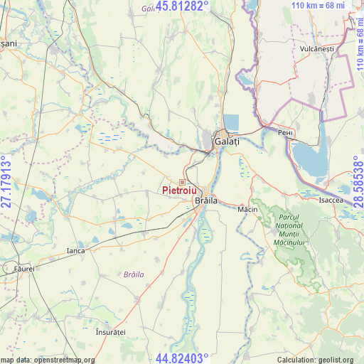
Pietroiu GPS coordinates[2]
45° 19' 14.088" North, 27° 52' 56.1" East
| Map corner | latitude | longitude |
|---|---|---|
| Upper-left | 45.81282°, | 27.17913° |
| Center: | 45.32058°, | 27.88225° |
| Lower-right: | 44.82403°, | 28.58538° |
| Map W x H: | 109.9×109.9 km | = 68.3×68.3mi |
| max Lat: | 48.23793° ⇑58.4% North |
| Pietroiu: | 45.32058° |
| min Lat: | ⇓41.6% South 43.65638° |
| min Long | Pietroiu | max Long |
| 20.31667° | 27.88225° | 29.65403° |
| W 95.1%⇐ | ⇒4.9% E |
Elevation
Elevation of Pietroiu is 6 m = 20 ft, and this is 248.9 m = 817 ft below average elevation for this country.
| Max E: |
1278 m = 4193 ft | 99.5% |
| Avg. | 254.9 m = 836 ft | |
| Pietroiu | 6 m = 20 ft | |
Min E: |
-2 m = -7 ft | 0.5% |
See also: Romania elevation on elevation.city.
Geographical zone
Pietroiu is located in North temperate zone (between Tropic of Cancer and the Arctic Circle). Distance of this North polar circle is 2362 km =1467.7 mi to North.| Distance of | km | miles | from Pietroiu |
|---|---|---|---|
| North Pole | 4967.9 | 3086.9 | to North |
| Arctic Circle | 2362 | 1467.7 | to North |
| Tropic Cancer | 2433.3 | 1512 | to South |
| Equator | 5039.2 | 3131.2 | to South |


Nearby cities:
15 places around Pietroiu: (largest is in red/bold)
• Baldovinești
2.3 km =1.4 mi,  86°
86°
• Braniştea
14.6 km =9.1 mi,  350°
350°
• Brăila
9 km =5.6 mi,  127°
127°
• Cazasu
5.5 km =3.4 mi,  173°
173°
• Chiscani
15.8 km =9.8 mi, 165°
• Lacu Sărat
11.3 km =7 mi,  177°
177°
• Movileni
11.4 km =7.1 mi,  33°
33°
• Romanu
12.4 km =7.7 mi,  250°
250°
• Scorțaru Vechi
15.1 km =9.4 mi,  221°
221°
• Siliştea
3.4 km =2.1 mi,  227°
227°
• Smârdan
10.2 km =6.3 mi,  111°
111°
• Tudor Vladimirescu
13.2 km =8.2 mi,  209°
209°
• Vădeni
6.5 km =4 mi,  37°
37°
• Şendreni
9.2 km =5.7 mi,  16°
16°
• Șerbeștii Vechi
11.2 km =7 mi,  358°
358°
Sources, notices
• [Note1] Compared only with cities in Romania existing in our database
• [Src1] Map data: © OpenStreetMap contributors (CC-BY-SA)
• [Src2] Other city data from geonames.org with taken over terms of usage.
• [Src3] Geographical zone / Annual Mean Temperature by Robert A. Rohde @ Wikipedia
