Pantazi geodata
Pantazi (Prahova) is a populated place; located in Romania in Europe/Bucharest (GMT+3) time zone. With population of 1,221 people, there are 3700 cities with bigger population in this country. Compared to other cities in Romania, 72% of cities are located further ↑North; 65.8% of cities are located further ←West and 70.2% of cities have higher elevation than Pantazi. Note1


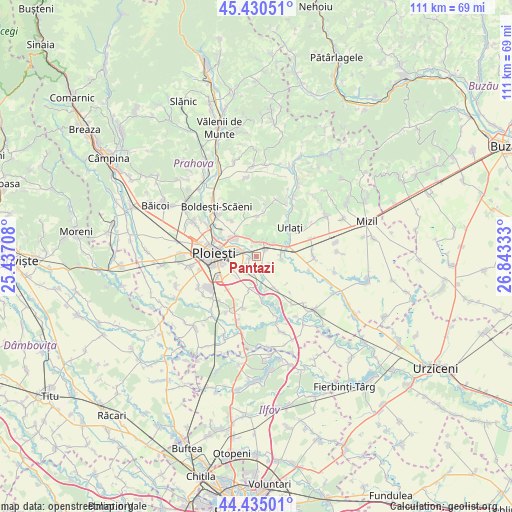
Pantazi GPS coordinates[2]
44° 56' 5.712" North, 26° 8' 24.72" East
| Map corner | latitude | longitude |
|---|---|---|
| Upper-left | 45.43051°, | 25.43708° |
| Center: | 44.93492°, | 26.1402° |
| Lower-right: | 44.43501°, | 26.84333° |
| Map W x H: | 110.7×110.7 km | = 68.8×68.8mi |
| max Lat: | 48.23793° ⇑72% North |
| Pantazi: | 44.93492° |
| min Lat: | ⇓28% South 43.65638° |
| min Long | Pantazi | max Long |
| 20.31667° | 26.1402° | 29.65403° |
| W 65.8%⇐ | ⇒34.2% E |
Elevation
Elevation of Pantazi is 126 m = 413 ft, and this is 128.9 m = 423 ft below average elevation for this country.
| Max E: |
1278 m = 4193 ft | 70.2% |
| Avg. | 254.9 m = 836 ft | |
| Pantazi | 126 m = 413 ft | |
Min E: |
-2 m = -7 ft | 29.8% |
See also: Romania elevation on elevation.city.
Geographical zone
Pantazi is located in North temperate zone (between Tropic of Cancer and the Arctic Circle). Distance of this Northern Tropic circle is 2390.4 km =1485.3 mi to South.| Distance of | km | miles | from Pantazi |
|---|---|---|---|
| North Pole | 5010.8 | 3113.6 | to North |
| Arctic Circle | 2404.9 | 1494.3 | to North |
| Tropic Cancer | 2390.4 | 1485.3 | to South |
| Equator | 4996.3 | 3104.6 | to South |


Nearby cities:
15 places around Pantazi: (largest is in red/bold)
• Albești-Muru
5.5 km =3.4 mi,  78°
78°
• Arva
3.2 km =2 mi,  30°
30°
• Berceni
1.9 km =1.2 mi,  264°
264°
• Chițorani
4.7 km =2.9 mi,  339°
339°
• Corlătești
4.8 km =3 mi,  240°
240°
• Coslegi
3.7 km =2.3 mi,  156°
156°
• Cătunu
3.8 km =2.4 mi,  185°
185°
• Dârvari
2.5 km =1.6 mi,  144°
144°
• Goga
5.4 km =3.4 mi,  178°
178°
• Moara Nouă
3 km =1.9 mi,  302°
302°
• Rachieri
2.4 km =1.5 mi, 336°
• Vadu Părului
5.5 km =3.4 mi,  94°
94°
• Valea Călugărească
3.6 km =2.2 mi,  12°
12°
• Valea Nicovani
5 km =3.1 mi,  51°
51°
• Valea Popii
3.4 km =2.1 mi,  347°
347°
Sources, notices
• [Note1] Compared only with cities in Romania existing in our database
• [Src1] Map data: © OpenStreetMap contributors (CC-BY-SA)
• [Src2] Other city data from geonames.org with taken over terms of usage.
• [Src3] Geographical zone / Annual Mean Temperature by Robert A. Rohde @ Wikipedia
