Nemțișor geodata
Nemțișor (Neamţ) is a populated place; located in Romania in Europe/Bucharest (GMT+3) time zone. With population of 1,595 people, there are 3056 cities with bigger population in this country. Compared to other cities in Romania, 85.2% of cities are located further ↓South; 68.2% of cities are located further ←West and 84.8% of cities have lower elevation than Nemțișor. Note1


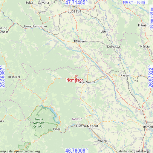
Nemțișor GPS coordinates[2]
47° 14' 22.632" North, 26° 16' 19.524" East
| Map corner | latitude | longitude |
|---|---|---|
| Upper-left | 47.71485°, | 25.56897° |
| Center: | 47.23962°, | 26.27209° |
| Lower-right: | 46.76009°, | 26.97522° |
| Map W x H: | 106.2×106.2 km | = 66×66mi |
| max Lat: | 48.23793° ⇑14.8% North |
| Nemțișor: | 47.23962° |
| min Lat: | ⇓85.2% South 43.65638° |
| min Long | Nemțișor | max Long |
| 20.31667° | 26.27209° | 29.65403° |
| W 68.2%⇐ | ⇒31.8% E |
Elevation
Elevation of Nemțișor is 444 m = 1457 ft, and this is 189.1 m = 620 ft above average elevation for this country.
| Max E: |
1278 m = 4193 ft | 15.2% |
| Nemțișor | 444 m 1457 ft | |
| Avg. | 254.9 m = 836 ft | |
Min E: |
-2 m = -7 ft | 84.8% |
See also: Romania elevation on elevation.city.
Geographical zone
Nemțișor is located in North temperate zone (between Tropic of Cancer and the Arctic Circle). Distance of this North polar circle is 2148.6 km =1335.1 mi to North.| Distance of | km | miles | from Nemțișor |
|---|---|---|---|
| North Pole | 4754.5 | 2954.3 | to North |
| Arctic Circle | 2148.6 | 1335.1 | to North |
| Tropic Cancer | 2646.6 | 1644.5 | to South |
| Equator | 5252.6 | 3263.8 | to South |


Nearby cities:
15 places around Nemțișor: (largest is in red/bold)
• Agapia
8.2 km =5.1 mi,  174°
174°
• Brusturi
9.7 km =6 mi,  59°
59°
• Filioara
8.8 km =5.5 mi,  176°
176°
• Humulești
7.6 km =4.7 mi,  126°
126°
• Leghin
5.8 km =3.6 mi,  253°
253°
• Lunca
2.5 km =1.6 mi,  122°
122°
• Moișa
10.4 km =6.5 mi,  6°
6°
• Oglinzi
6 km =3.7 mi,  78°
78°
• Poiana
9.3 km =5.8 mi,  46°
46°
• Săcuța
8.8 km =5.5 mi, 10°
• Săcălușești
9.3 km =5.8 mi,  146°
146°
• Târgu Neamţ
8.4 km =5.2 mi, 121°
• Târzia
10.5 km =6.5 mi,  38°
38°
• Varatec
10.7 km =6.6 mi, 178°
• Vânători-Neamţ
5.5 km =3.4 mi,  142°
142°
Sources, notices
• [Note1] Compared only with cities in Romania existing in our database
• [Src1] Map data: © OpenStreetMap contributors (CC-BY-SA)
• [Src2] Other city data from geonames.org with taken over terms of usage.
• [Src3] Geographical zone / Annual Mean Temperature by Robert A. Rohde @ Wikipedia
