Mustățești geodata
Mustățești (Arges) is a populated place; located in Romania in Europe/Bucharest (GMT+3) time zone. With population of 604 people, there are 6177 cities with bigger population in this country. Compared to other cities in Romania, 61.8% of cities are located further ↑North; 57.5% of cities are located further →East and 88.3% of cities have lower elevation than Mustățești. Note1


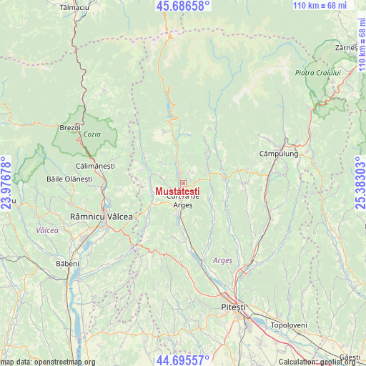
Mustățești GPS coordinates[2]
45° 11' 35.628" North, 24° 40' 47.64" East
| Map corner | latitude | longitude |
|---|---|---|
| Upper-left | 45.68658°, | 23.97678° |
| Center: | 45.19323°, | 24.6799° |
| Lower-right: | 44.69557°, | 25.38303° |
| Map W x H: | 110.2×110.2 km | = 68.5×68.5mi |
| max Lat: | 48.23793° ⇑61.8% North |
| Mustățești: | 45.19323° |
| min Lat: | ⇓38.2% South 43.65638° |
| min Long | Mustățești | max Long |
| 20.31667° | 24.6799° | 29.65403° |
| W 42.5%⇐ | ⇒57.5% E |
Elevation
Elevation of Mustățești is 488 m = 1601 ft, and this is 233.1 m = 765 ft above average elevation for this country.
| Max E: |
1278 m = 4193 ft | 11.7% |
| Mustățești | 488 m 1601 ft | |
| Avg. | 254.9 m = 836 ft | |
Min E: |
-2 m = -7 ft | 88.3% |
See also: Romania elevation on elevation.city.
Geographical zone
Mustățești is located in North temperate zone (between Tropic of Cancer and the Arctic Circle). Distance of this North polar circle is 2376.2 km =1476.5 mi to North.| Distance of | km | miles | from Mustățești |
|---|---|---|---|
| North Pole | 4982 | 3095.7 | to North |
| Arctic Circle | 2376.2 | 1476.5 | to North |
| Tropic Cancer | 2419.1 | 1503.2 | to South |
| Equator | 5025 | 3122.4 | to South |


Nearby cities:
15 places around Mustățești: (largest is in red/bold)
• Albeştii Pământeni
2.8 km =1.7 mi,  338°
338°
• Albeştii de Argeş
2.8 km =1.7 mi, 338°
• Albeștii Ungureni
3.6 km =2.2 mi,  350°
350°
• Brătești
4.2 km =2.6 mi,  32°
32°
• Cerbureni
2 km =1.2 mi,  37°
37°
• Cicănești
8.3 km =5.2 mi,  315°
315°
• Curtea de Argeş
6.6 km =4.1 mi,  183°
183°
• Dobrotu
2.2 km =1.4 mi,  311°
311°
• Mușătești
8.2 km =5.1 mi,  71°
71°
• Oeștii Pământeni
6.8 km =4.2 mi, 344°
• Oeștii Ungureni
7.1 km =4.4 mi, 339°
• Robaia
8.2 km =5.1 mi, 71°
• Valea Danului
2.6 km =1.6 mi,  244°
244°
• Valea Iaşului
3.1 km =1.9 mi,  110°
110°
• Vernești
5.8 km =3.6 mi,  277°
277°
Sources, notices
• [Note1] Compared only with cities in Romania existing in our database
• [Src1] Map data: © OpenStreetMap contributors (CC-BY-SA)
• [Src2] Other city data from geonames.org with taken over terms of usage.
• [Src3] Geographical zone / Annual Mean Temperature by Robert A. Rohde @ Wikipedia
