Muşeteşti geodata
Muşeteşti (Gorj) is a seat of a second-order administrative division; located in Romania in Europe/Bucharest (GMT+3) time zone. With population of 2,270 people, there are 2351 cities with bigger population in this country. Compared to other cities in Romania, 63.6% of cities are located further ↑North; 77.6% of cities are located further →East and 77% of cities have lower elevation than Muşeteşti. Note1


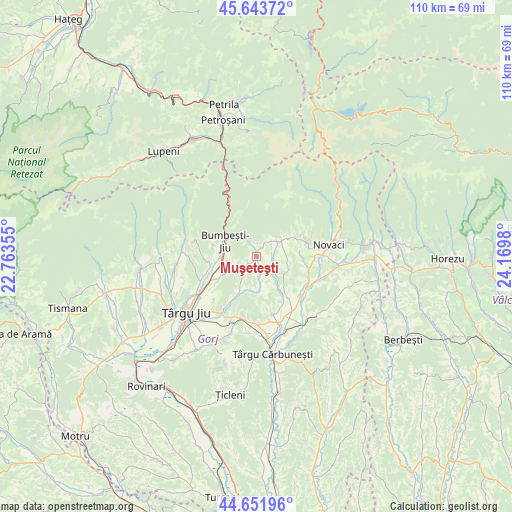
Muşeteşti GPS coordinates[2]
45° 9' 0" North, 23° 28' 0.012" East
| Map corner | latitude | longitude |
|---|---|---|
| Upper-left | 45.64372°, | 22.76355° |
| Center: | 45.15°, | 23.46667° |
| Lower-right: | 44.65196°, | 24.1698° |
| Map W x H: | 110.3×110.3 km | = 68.5×68.5mi |
| max Lat: | 48.23793° ⇑63.6% North |
| Muşeteşti: | 45.15° |
| min Lat: | ⇓36.4% South 43.65638° |
| min Long | Muşeteşti | max Long |
| 20.31667° | 23.46667° | 29.65403° |
| W 22.4%⇐ | ⇒77.6% E |
Elevation
Elevation of Muşeteşti is 368 m = 1207 ft, and this is 113.1 m = 371 ft above average elevation for this country.
| Max E: |
1278 m = 4193 ft | 23% |
| Muşeteşti | 368 m 1207 ft | |
| Avg. | 254.9 m = 836 ft | |
Min E: |
-2 m = -7 ft | 77% |
See also: Romania elevation on elevation.city.
Geographical zone
Muşeteşti is located in North temperate zone (between Tropic of Cancer and the Arctic Circle). Distance of this North polar circle is 2381 km =1479.5 mi to North.| Distance of | km | miles | from Muşeteşti |
|---|---|---|---|
| North Pole | 4986.9 | 3098.7 | to North |
| Arctic Circle | 2381 | 1479.5 | to North |
| Tropic Cancer | 2414.3 | 1500.2 | to South |
| Equator | 5020.2 | 3119.4 | to South |


Nearby cities:
15 places around Muşeteşti: (largest is in red/bold)
• Blahnița de Sus
6.8 km =4.2 mi,  103°
103°
• Bumbeşti-Jiu
5.5 km =3.4 mi,  289°
289°
• Bălăneşti
10.6 km =6.6 mi,  209°
209°
• Crasna
3.2 km =2 mi,  54°
54°
• Crasna din Deal
7.2 km =4.5 mi,  57°
57°
• Curtișoara
9.7 km =6 mi,  238°
238°
• Cărpiniș
9.7 km =6 mi,  67°
67°
• Drăgoiești
4.6 km =2.9 mi,  44°
44°
• Dumbrăveni
3.7 km =2.3 mi,  90°
90°
• Glodeni
7.6 km =4.7 mi,  182°
182°
• Gornăcel
9.7 km =6 mi, 285°
• Magherești
7.7 km =4.8 mi,  144°
144°
• Săcelu
7.6 km =4.7 mi, 136°
• Tetila
7 km =4.3 mi, 244°
• Voiteștii din Vale
7.8 km =4.8 mi, 207°
Sources, notices
• [Note1] Compared only with cities in Romania existing in our database
• [Src1] Map data: © OpenStreetMap contributors (CC-BY-SA)
• [Src2] Other city data from geonames.org with taken over terms of usage.
• [Src3] Geographical zone / Annual Mean Temperature by Robert A. Rohde @ Wikipedia
