Mugeni geodata
Mugeni (Harghita) is a seat of a second-order administrative division; located in Romania in Europe/Bucharest (GMT+3) time zone. With population of 5,784 people, there are 584 cities with bigger population in this country. Compared to other cities in Romania, 60.8% of cities are located further ↓South; 50.1% of cities are located further ←West and 85.2% of cities have lower elevation than Mugeni. Note1


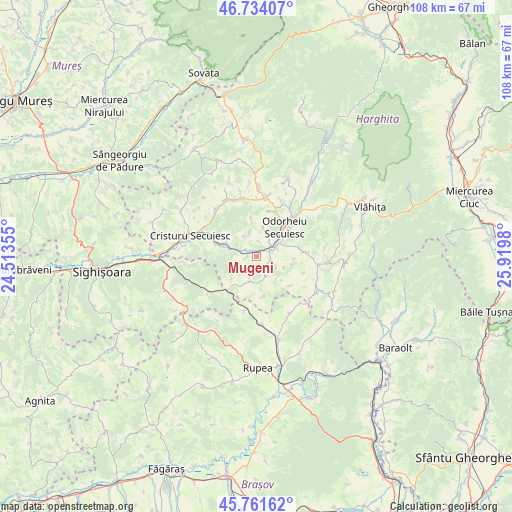
Mugeni GPS coordinates[2]
46° 15' 0" North, 25° 13' 0.012" East
| Map corner | latitude | longitude |
|---|---|---|
| Upper-left | 46.73407°, | 24.51355° |
| Center: | 46.25°, | 25.21667° |
| Lower-right: | 45.76162°, | 25.9198° |
| Map W x H: | 108.1×108.1 km | = 67.2×67.2mi |
| max Lat: | 48.23793° ⇑39.2% North |
| Mugeni: | 46.25° |
| min Lat: | ⇓60.8% South 43.65638° |
| min Long | Mugeni | max Long |
| 20.31667° | 25.21667° | 29.65403° |
| W 50.1%⇐ | ⇒49.9% E |
Elevation
Elevation of Mugeni is 448 m = 1470 ft, and this is 193.1 m = 634 ft above average elevation for this country.
| Max E: |
1278 m = 4193 ft | 14.8% |
| Mugeni | 448 m 1470 ft | |
| Avg. | 254.9 m = 836 ft | |
Min E: |
-2 m = -7 ft | 85.2% |
See also: Romania elevation on elevation.city.
Geographical zone
Mugeni is located in North temperate zone (between Tropic of Cancer and the Arctic Circle). Distance of this North polar circle is 2258.7 km =1403.5 mi to North.| Distance of | km | miles | from Mugeni |
|---|---|---|---|
| North Pole | 4864.5 | 3022.7 | to North |
| Arctic Circle | 2258.7 | 1403.5 | to North |
| Tropic Cancer | 2536.6 | 1576.2 | to South |
| Equator | 5142.5 | 3195.4 | to South |


Nearby cities:
15 places around Mugeni: (largest is in red/bold)
• Archita
12.6 km =7.8 mi,  232°
232°
• Betești
11.2 km =7 mi,  293°
293°
• Bisericani
13.3 km =8.3 mi,  8°
8°
• Dobeni
4.7 km =2.9 mi,  332°
332°
• Drăușeni
14.1 km =8.8 mi,  149°
149°
• Dârjiu
5.7 km =3.5 mi,  192°
192°
• Feliceni
4.3 km =2.7 mi,  64°
64°
• Lutița
2.1 km =1.3 mi,  261°
261°
• Morăreni
12.2 km =7.6 mi,  1°
1°
• Mărtiniş
12.9 km =8 mi,  98°
98°
• Odorheiu Secuiesc
8.5 km =5.3 mi,  49°
49°
• Porumbenii Mari
6.8 km =4.2 mi, 294°
• Rugănești
12.6 km =7.8 mi,  298°
298°
• Simoneşti
12.9 km =8 mi,  315°
315°
• Tăureni
3.2 km =2 mi, 54°
Sources, notices
• [Note1] Compared only with cities in Romania existing in our database
• [Src1] Map data: © OpenStreetMap contributors (CC-BY-SA)
• [Src2] Other city data from geonames.org with taken over terms of usage.
• [Src3] Geographical zone / Annual Mean Temperature by Robert A. Rohde @ Wikipedia
