Moișeni geodata
Moișeni (Satu Mare) is a populated place; located in Romania in Europe/Bucharest (GMT+3) time zone. With population of 1,327 people, there are 3469 cities with bigger population in this country. Compared to other cities in Romania, 98.4% of cities are located further ↓South; 77.4% of cities are located further →East and 60.2% of cities have lower elevation than Moișeni. Note1


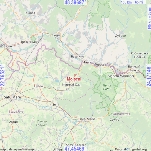
Moișeni GPS coordinates[2]
47° 55' 40.728" North, 23° 28' 5.988" East
| Map corner | latitude | longitude |
|---|---|---|
| Upper-left | 48.39697°, | 22.76521° |
| Center: | 47.92798°, | 23.46833° |
| Lower-right: | 47.45469°, | 24.17146° |
| Map W x H: | 104.8×104.8 km | = 65.1×65.1mi |
| max Lat: | 48.23793° ⇑1.6% North |
| Moișeni: | 47.92798° |
| min Lat: | ⇓98.4% South 43.65638° |
| min Long | Moișeni | max Long |
| 20.31667° | 23.46833° | 29.65403° |
| W 22.6%⇐ | ⇒77.4% E |
Elevation
Elevation of Moișeni is 264 m = 866 ft, and this is 9.1 m = 30 ft above average elevation for this country.
| Max E: |
1278 m = 4193 ft | 39.8% |
| Moișeni | 264 m 866 ft | |
| Avg. | 254.9 m = 836 ft | |
Min E: |
-2 m = -7 ft | 60.2% |
See also: Romania elevation on elevation.city.
Geographical zone
Moișeni is located in North temperate zone (between Tropic of Cancer and the Arctic Circle). Distance of this North polar circle is 2072.1 km =1287.5 mi to North.| Distance of | km | miles | from Moișeni |
|---|---|---|---|
| North Pole | 4678 | 2906.8 | to North |
| Arctic Circle | 2072.1 | 1287.5 | to North |
| Tropic Cancer | 2723.2 | 1692.1 | to South |
| Equator | 5329.1 | 3311.3 | to South |


Nearby cities:
15 places around Moișeni: (largest is in red/bold)
• Bixad
5.1 km =3.2 mi,  276°
276°
• Boinești
8.8 km =5.5 mi,  261°
261°
• Certeze
3.1 km =1.9 mi,  182°
182°
• Călineşti-Oaş
12.9 km =8 mi, 256°
• Huta Certeze
1.4 km =0.9 mi,  99°
99°
• Lechința
12.7 km =7.9 mi,  267°
267°
• Luna
9 km =5.6 mi,  194°
194°
• Negreşti-Oaş
7.3 km =4.5 mi,  200°
200°
• Remetea Oașului
12.6 km =7.8 mi,  242°
242°
• Remeţi
13.7 km =8.5 mi,  63°
63°
• Trip
6.9 km =4.3 mi, 266°
• Tur
7.7 km =4.8 mi,  228°
228°
• Târşolţ
9.1 km =5.7 mi,  285°
285°
• Târşolţel
9.1 km =5.7 mi, 285°
• Vama
11.7 km =7.3 mi,  205°
205°
Sources, notices
• [Note1] Compared only with cities in Romania existing in our database
• [Src1] Map data: © OpenStreetMap contributors (CC-BY-SA)
• [Src2] Other city data from geonames.org with taken over terms of usage.
• [Src3] Geographical zone / Annual Mean Temperature by Robert A. Rohde @ Wikipedia
