Mlăjet geodata
Mlăjet (Buzău) is a populated place; located in Romania in Europe/Bucharest (GMT+3) time zone. With population of 881 people, there are 4699 cities with bigger population in this country. Compared to other cities in Romania, 57.4% of cities are located further ↑North; 69.6% of cities are located further ←West and 72.2% of cities have lower elevation than Mlăjet. Note1


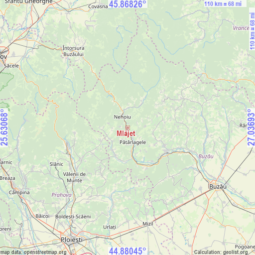
Mlăjet GPS coordinates[2]
45° 22' 35.436" North, 26° 20' 1.68" East
| Map corner | latitude | longitude |
|---|---|---|
| Upper-left | 45.86826°, | 25.63068° |
| Center: | 45.37651°, | 26.3338° |
| Lower-right: | 44.88045°, | 27.03693° |
| Map W x H: | 109.8×109.8 km | = 68.2×68.2mi |
| max Lat: | 48.23793° ⇑57.4% North |
| Mlăjet: | 45.37651° |
| min Lat: | ⇓42.6% South 43.65638° |
| min Long | Mlăjet | max Long |
| 20.31667° | 26.3338° | 29.65403° |
| W 69.6%⇐ | ⇒30.4% E |
Elevation
Elevation of Mlăjet is 335 m = 1099 ft, and this is 80.1 m = 263 ft above average elevation for this country.
| Max E: |
1278 m = 4193 ft | 27.8% |
| Mlăjet | 335 m 1099 ft | |
| Avg. | 254.9 m = 836 ft | |
Min E: |
-2 m = -7 ft | 72.2% |
See also: Romania elevation on elevation.city.
Geographical zone
Mlăjet is located in North temperate zone (between Tropic of Cancer and the Arctic Circle). Distance of this North polar circle is 2355.8 km =1463.8 mi to North.| Distance of | km | miles | from Mlăjet |
|---|---|---|---|
| North Pole | 4961.7 | 3083.1 | to North |
| Arctic Circle | 2355.8 | 1463.8 | to North |
| Tropic Cancer | 2439.5 | 1515.8 | to South |
| Equator | 5045.4 | 3135.1 | to South |


Nearby cities:
15 places around Mlăjet: (largest is in red/bold)
• Babeţi
7.7 km =4.8 mi,  149°
149°
• Burueneşti
6.8 km =4.2 mi,  169°
169°
• Bâsca Rozilei
8.6 km =5.3 mi,  1°
1°
• Colţi
3.9 km =2.4 mi,  78°
78°
• Crâng
6.8 km =4.2 mi, 169°
• Cătiașu
8.5 km =5.3 mi,  283°
283°
• Lunca Priporului
7.2 km =4.5 mi,  344°
344°
• Nehoiu
5.2 km =3.2 mi,  329°
329°
• Păltineni
2.3 km =1.4 mi, 339°
• Pănătău
7.8 km =4.8 mi,  142°
142°
• Pătârlagele
6.6 km =4.1 mi,  160°
160°
• Sibiciu de Jos
7.3 km =4.5 mi, 152°
• Sibiciu de Sus
5 km =3.1 mi, 152°
• Valea Lupului
3 km =1.9 mi, 162°
• Valea Viei
7.5 km =4.7 mi, 170°
Sources, notices
• [Note1] Compared only with cities in Romania existing in our database
• [Src1] Map data: © OpenStreetMap contributors (CC-BY-SA)
• [Src2] Other city data from geonames.org with taken over terms of usage.
• [Src3] Geographical zone / Annual Mean Temperature by Robert A. Rohde @ Wikipedia
