Miloşeşti geodata
Miloşeşti (Ialomiţa) is a seat of a second-order administrative division; located in Romania in Europe/Bucharest (GMT+3) time zone. With population of 3,056 people, there are 1726 cities with bigger population in this country. Compared to other cities in Romania, 79% of cities are located further ↑North; 87.3% of cities are located further ←West and 92.2% of cities have higher elevation than Miloşeşti. Note1


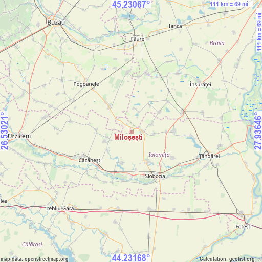
Miloşeşti GPS coordinates[2]
44° 43' 59.988" North, 27° 13' 59.988" East
| Map corner | latitude | longitude |
|---|---|---|
| Upper-left | 45.23067°, | 26.53021° |
| Center: | 44.73333°, | 27.23333° |
| Lower-right: | 44.23168°, | 27.93646° |
| Map W x H: | 111.1×111.1 km | = 69×69mi |
| max Lat: | 48.23793° ⇑79% North |
| Miloşeşti: | 44.73333° |
| min Lat: | ⇓21% South 43.65638° |
| min Long | Miloşeşti | max Long |
| 20.31667° | 27.23333° | 29.65403° |
| W 87.3%⇐ | ⇒12.7% E |
Elevation
Elevation of Miloşeşti is 48 m = 157 ft, and this is 206.9 m = 679 ft below average elevation for this country.
| Max E: |
1278 m = 4193 ft | 92.2% |
| Avg. | 254.9 m = 836 ft | |
| Miloşeşti | 48 m = 157 ft | |
Min E: |
-2 m = -7 ft | 7.8% |
See also: Romania elevation on elevation.city.
Geographical zone
Miloşeşti is located in North temperate zone (between Tropic of Cancer and the Arctic Circle). Distance of this Northern Tropic circle is 2368 km =1471.4 mi to South.| Distance of | km | miles | from Miloşeşti |
|---|---|---|---|
| North Pole | 5033.2 | 3127.5 | to North |
| Arctic Circle | 2427.3 | 1508.3 | to North |
| Tropic Cancer | 2368 | 1471.4 | to South |
| Equator | 4973.9 | 3090.6 | to South |


Nearby cities:
15 places around Miloşeşti: (largest is in red/bold)
• Amara
14.5 km =9 mi,  153°
153°
• Ciocile
9.3 km =5.8 mi,  0°
0°
• Cocora
14.5 km =9 mi,  270°
270°
• Colțea
14.8 km =9.2 mi,  32°
32°
• Crunți
12.6 km =7.8 mi,  230°
230°
• Gheorghe Doja
13.5 km =8.4 mi,  195°
195°
• Griviţa
3.9 km =2.4 mi,  90°
90°
• Iazu
14.8 km =9.2 mi, 90°
• Nicolești
3.3 km =2.1 mi,  330°
330°
• Padina
14.4 km =8.9 mi,  320°
320°
• Reviga
10.7 km =6.6 mi,  260°
260°
• Rovine
11.8 km =7.3 mi,  249°
249°
• Roşiori
14 km =8.7 mi,  57°
57°
• Smirna
9.6 km =6 mi,  96°
96°
• Traian
9.3 km =5.8 mi,  68°
68°
Sources, notices
• [Note1] Compared only with cities in Romania existing in our database
• [Src1] Map data: © OpenStreetMap contributors (CC-BY-SA)
• [Src2] Other city data from geonames.org with taken over terms of usage.
• [Src3] Geographical zone / Annual Mean Temperature by Robert A. Rohde @ Wikipedia
