Mihoveni geodata
Mihoveni (Suceava) is a populated place; located in Romania in Europe/Bucharest (GMT+3) time zone. With population of 2,152 people, there are 2468 cities with bigger population in this country. Compared to other cities in Romania, 94.5% of cities are located further ↓South; 66.5% of cities are located further ←West and 77.8% of cities have lower elevation than Mihoveni. Note1


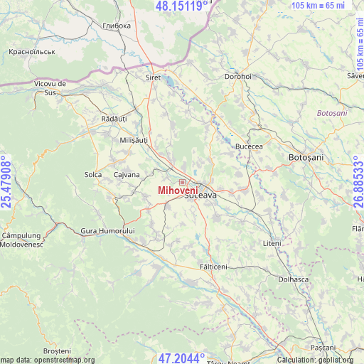
Mihoveni GPS coordinates[2]
47° 40' 47.784" North, 26° 10' 55.92" East
| Map corner | latitude | longitude |
|---|---|---|
| Upper-left | 48.15119°, | 25.47908° |
| Center: | 47.67994°, | 26.1822° |
| Lower-right: | 47.2044°, | 26.88533° |
| Map W x H: | 105.3×105.3 km | = 65.4×65.4mi |
| max Lat: | 48.23793° ⇑5.5% North |
| Mihoveni: | 47.67994° |
| min Lat: | ⇓94.5% South 43.65638° |
| min Long | Mihoveni | max Long |
| 20.31667° | 26.1822° | 29.65403° |
| W 66.5%⇐ | ⇒33.5% E |
Elevation
Elevation of Mihoveni is 374 m = 1227 ft, and this is 119.1 m = 391 ft above average elevation for this country.
| Max E: |
1278 m = 4193 ft | 22.2% |
| Mihoveni | 374 m 1227 ft | |
| Avg. | 254.9 m = 836 ft | |
Min E: |
-2 m = -7 ft | 77.8% |
See also: Romania elevation on elevation.city.
Geographical zone
Mihoveni is located in North temperate zone (between Tropic of Cancer and the Arctic Circle). Distance of this North polar circle is 2099.7 km =1304.7 mi to North.| Distance of | km | miles | from Mihoveni |
|---|---|---|---|
| North Pole | 4705.5 | 2923.9 | to North |
| Arctic Circle | 2099.7 | 1304.7 | to North |
| Tropic Cancer | 2695.6 | 1675 | to South |
| Equator | 5301.5 | 3294.2 | to South |


Nearby cities:
15 places around Mihoveni: (largest is in red/bold)
• Bulai
7.7 km =4.8 mi,  157°
157°
• Costâna
4.9 km =3 mi,  286°
286°
• Dănila
10 km =6.2 mi,  323°
323°
• Dărmăneşti
6.4 km =4 mi,  337°
337°
• Lipoveni
5.9 km =3.7 mi,  33°
33°
• Lisaura
9.8 km =6.1 mi,  118°
118°
• Mitocași
8.3 km =5.2 mi,  46°
46°
• Mitocu Dragomirnei
7.8 km =4.8 mi,  40°
40°
• Moara Nica
9.3 km =5.8 mi, 160°
• Măriței
8.5 km =5.3 mi, 341°
• Părhăuți
7.7 km =4.8 mi,  296°
296°
• Pătrăuţi
4.3 km =2.7 mi,  18°
18°
• Scheia
5.1 km =3.2 mi,  131°
131°
• Stroiești
7.9 km =4.9 mi,  207°
207°
• Suceava
7.3 km =4.5 mi,  135°
135°
Sources, notices
• [Note1] Compared only with cities in Romania existing in our database
• [Src1] Map data: © OpenStreetMap contributors (CC-BY-SA)
• [Src2] Other city data from geonames.org with taken over terms of usage.
• [Src3] Geographical zone / Annual Mean Temperature by Robert A. Rohde @ Wikipedia
