Mereni geodata
Mereni (Covasna) is a seat of a second-order administrative division; located in Romania in Europe/Bucharest (GMT+3) time zone. With population of 970 people, there are 4385 cities with bigger population in this country. Compared to other cities in Romania, 56.8% of cities are located further ↓South; 67.6% of cities are located further ←West and 94.6% of cities have lower elevation than Mereni. Note1


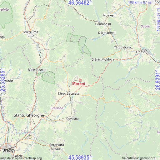
Mereni GPS coordinates[2]
46° 4' 45.264" North, 26° 14' 9.492" East
| Map corner | latitude | longitude |
|---|---|---|
| Upper-left | 46.56482°, | 25.53285° |
| Center: | 46.07924°, | 26.23597° |
| Lower-right: | 45.58935°, | 26.9391° |
| Map W x H: | 108.5×108.5 km | = 67.4×67.4mi |
| max Lat: | 48.23793° ⇑43.2% North |
| Mereni: | 46.07924° |
| min Lat: | ⇓56.8% South 43.65638° |
| min Long | Mereni | max Long |
| 20.31667° | 26.23597° | 29.65403° |
| W 67.6%⇐ | ⇒32.4% E |
Elevation
Elevation of Mereni is 615 m = 2018 ft, and this is 360.1 m = 1181 ft above average elevation for this country.
| Max E: |
1278 m = 4193 ft | 5.4% |
| Mereni | 615 m 2018 ft | |
| Avg. | 254.9 m = 836 ft | |
Min E: |
-2 m = -7 ft | 94.6% |
See also: Romania elevation on elevation.city.
Geographical zone
Mereni is located in North temperate zone (between Tropic of Cancer and the Arctic Circle). Distance of this North polar circle is 2277.6 km =1415.2 mi to North.| Distance of | km | miles | from Mereni |
|---|---|---|---|
| North Pole | 4883.5 | 3034.5 | to North |
| Arctic Circle | 2277.6 | 1415.2 | to North |
| Tropic Cancer | 2517.6 | 1564.4 | to South |
| Equator | 5123.5 | 3183.6 | to South |


Nearby cities:
15 places around Mereni: (largest is in red/bold)
• Breţcu
5.9 km =3.7 mi,  123°
123°
• Catalina
14.2 km =8.8 mi,  207°
207°
• Estelnic
3.3 km =2.1 mi,  327°
327°
• Ghelinţa
14.4 km =8.9 mi,  180°
180°
• Lemnia
4 km =2.5 mi,  143°
143°
• Lunga
7 km =4.3 mi,  195°
195°
• Lutoasa
1.3 km =0.8 mi,  350°
350°
• Mărtănuș
7.9 km =4.9 mi,  146°
146°
• Ojdula
10.7 km =6.6 mi,  174°
174°
• Petriceni
11.6 km =7.2 mi,  263°
263°
• Poian
6.8 km =4.2 mi, 258°
• Sânzieni
8.6 km =5.3 mi,  247°
247°
• Turia
15.2 km =9.4 mi, 250°
• Târgu Secuiesc
11.8 km =7.3 mi,  221°
221°
• Valea Seacă
9 km =5.6 mi,  273°
273°
Sources, notices
• [Note1] Compared only with cities in Romania existing in our database
• [Src1] Map data: © OpenStreetMap contributors (CC-BY-SA)
• [Src2] Other city data from geonames.org with taken over terms of usage.
• [Src3] Geographical zone / Annual Mean Temperature by Robert A. Rohde @ Wikipedia
