Măgura geodata
Măgura (Caraş-Severin) is a populated place; located in Romania in Europe/Bucharest (GMT+3) time zone. With population of 539 people, there are 6689 cities with bigger population in this country. Compared to other cities in Romania, 55.3% of cities are located further ↑North; 90.5% of cities are located further →East and 73% of cities have lower elevation than Măgura. Note1


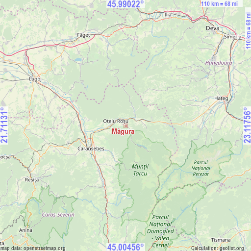
Măgura GPS coordinates[2]
45° 29' 58.38" North, 22° 24' 51.948" East
| Map corner | latitude | longitude |
|---|---|---|
| Upper-left | 45.99022°, | 21.71131° |
| Center: | 45.49955°, | 22.41443° |
| Lower-right: | 45.00456°, | 23.11756° |
| Map W x H: | 109.6×109.6 km | = 68.1×68.1mi |
| max Lat: | 48.23793° ⇑55.3% North |
| Măgura: | 45.49955° |
| min Lat: | ⇓44.7% South 43.65638° |
| min Long | Măgura | max Long |
| 20.31667° | 22.41443° | 29.65403° |
| W 9.5%⇐ | ⇒90.5% E |
Elevation
Elevation of Măgura is 340 m = 1115 ft, and this is 85.1 m = 279 ft above average elevation for this country.
| Max E: |
1278 m = 4193 ft | 27% |
| Măgura | 340 m 1115 ft | |
| Avg. | 254.9 m = 836 ft | |
Min E: |
-2 m = -7 ft | 73% |
See also: Romania elevation on elevation.city.
Geographical zone
Măgura is located in North temperate zone (between Tropic of Cancer and the Arctic Circle). Distance of this North polar circle is 2342.1 km =1455.3 mi to North.| Distance of | km | miles | from Măgura |
|---|---|---|---|
| North Pole | 4948 | 3074.5 | to North |
| Arctic Circle | 2342.1 | 1455.3 | to North |
| Tropic Cancer | 2453.2 | 1524.3 | to South |
| Equator | 5059.1 | 3143.6 | to South |


Nearby cities:
15 places around Măgura: (largest is in red/bold)
• 23 August
2.9 km =1.8 mi,  335°
335°
• Băuţar
12 km =7.5 mi,  80°
80°
• Cireșa
3.6 km =2.2 mi,  325°
325°
• Glimboca
7.8 km =4.8 mi,  256°
256°
• Iaz
14.6 km =9.1 mi,  254°
254°
• Marga
8 km =5 mi,  89°
89°
• Muntele Mic
14.4 km =8.9 mi,  206°
206°
• Măru
3.8 km =2.4 mi,  133°
133°
• Obreja
12.9 km =8 mi, 261°
• Oţelu Roşu
5.3 km =3.3 mi,  315°
315°
• Rusca Montană
8.3 km =5.2 mi,  24°
24°
• Turnu Ruieni
13.6 km =8.5 mi, 206°
• Voislova
4.7 km =2.9 mi,  48°
48°
• Zervești
14 km =8.7 mi,  222°
222°
• Zăvoi
1.9 km =1.2 mi,  5°
5°
Sources, notices
• [Note1] Compared only with cities in Romania existing in our database
• [Src1] Map data: © OpenStreetMap contributors (CC-BY-SA)
• [Src2] Other city data from geonames.org with taken over terms of usage.
• [Src3] Geographical zone / Annual Mean Temperature by Robert A. Rohde @ Wikipedia
