Leliceni geodata
Leliceni (Harghita) is a seat of a second-order administrative division; located in Romania in Europe/Bucharest (GMT+3) time zone. With population of 270 people, there are 7061 cities with bigger population in this country. Compared to other cities in Romania, 63.3% of cities are located further ↓South; 60% of cities are located further ←West and 97% of cities have lower elevation than Leliceni. Note1


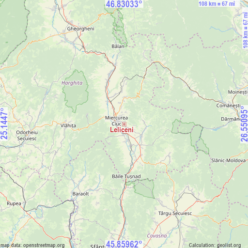
Leliceni GPS coordinates[2]
46° 20' 49.668" North, 25° 50' 52.152" East
| Map corner | latitude | longitude |
|---|---|---|
| Upper-left | 46.83033°, | 25.1447° |
| Center: | 46.34713°, | 25.84782° |
| Lower-right: | 45.85962°, | 26.55095° |
| Map W x H: | 107.9×107.9 km | = 67×67mi |
| max Lat: | 48.23793° ⇑36.7% North |
| Leliceni: | 46.34713° |
| min Lat: | ⇓63.3% South 43.65638° |
| min Long | Leliceni | max Long |
| 20.31667° | 25.84782° | 29.65403° |
| W 60%⇐ | ⇒40% E |
Elevation
Elevation of Leliceni is 717 m = 2352 ft, and this is 462.1 m = 1516 ft above average elevation for this country.
| Max E: |
1278 m = 4193 ft | 3% |
| Leliceni | 717 m 2352 ft | |
| Avg. | 254.9 m = 836 ft | |
Min E: |
-2 m = -7 ft | 97% |
See also: Romania elevation on elevation.city.
Geographical zone
Leliceni is located in North temperate zone (between Tropic of Cancer and the Arctic Circle). Distance of this North polar circle is 2247.9 km =1396.8 mi to North.| Distance of | km | miles | from Leliceni |
|---|---|---|---|
| North Pole | 4853.7 | 3015.9 | to North |
| Arctic Circle | 2247.9 | 1396.8 | to North |
| Tropic Cancer | 2547.4 | 1582.9 | to South |
| Equator | 5153.3 | 3202.1 | to South |


Nearby cities:
15 places around Leliceni: (largest is in red/bold)
• Armășeni
8.7 km =5.4 mi,  85°
85°
• Bancu
8.9 km =5.5 mi,  123°
123°
• Bârzava
9.7 km =6 mi,  347°
347°
• Ciceu
8.9 km =5.5 mi,  325°
325°
• Ciucsângeorgiu
8.5 km =5.3 mi,  113°
113°
• Delnița
7.4 km =4.6 mi, 349°
• Miercurea-Ciuc
3.7 km =2.3 mi,  274°
274°
• Misentea
4.3 km =2.7 mi, 121°
• Nicolești
10.2 km =6.3 mi,  358°
358°
• Păuleni-Ciuc
6 km =3.7 mi, 349°
• Siculeni
10.8 km =6.7 mi,  315°
315°
• Sâncrăieni
3.7 km =2.3 mi,  190°
190°
• Sânmartin
11.1 km =6.9 mi,  143°
143°
• Sântimbru
7.3 km =4.5 mi,  176°
176°
• Șoimeni
5.3 km =3.3 mi,  7°
7°
Sources, notices
• [Note1] Compared only with cities in Romania existing in our database
• [Src1] Map data: © OpenStreetMap contributors (CC-BY-SA)
• [Src2] Other city data from geonames.org with taken over terms of usage.
• [Src3] Geographical zone / Annual Mean Temperature by Robert A. Rohde @ Wikipedia
