Lăzărești geodata
Lăzărești (Harghita) is a populated place; located in Romania in Europe/Bucharest (GMT+3) time zone. With population of 620 people, there are 6077 cities with bigger population in this country. Compared to other cities in Romania, 59.4% of cities are located further ↓South; 61.7% of cities are located further ←West and 96.7% of cities have lower elevation than Lăzărești. Note1


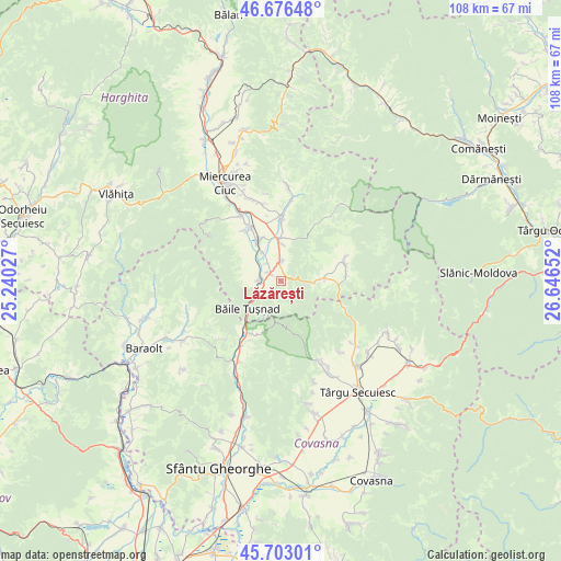
Lăzărești GPS coordinates[2]
46° 11' 30.84" North, 25° 56' 36.204" East
| Map corner | latitude | longitude |
|---|---|---|
| Upper-left | 46.67648°, | 25.24027° |
| Center: | 46.1919°, | 25.94339° |
| Lower-right: | 45.70301°, | 26.64652° |
| Map W x H: | 108.2×108.2 km | = 67.2×67.2mi |
| max Lat: | 48.23793° ⇑40.6% North |
| Lăzărești: | 46.1919° |
| min Lat: | ⇓59.4% South 43.65638° |
| min Long | Lăzărești | max Long |
| 20.31667° | 25.94339° | 29.65403° |
| W 61.7%⇐ | ⇒38.3% E |
Elevation
Elevation of Lăzărești is 699 m = 2293 ft, and this is 444.1 m = 1457 ft above average elevation for this country.
| Max E: |
1278 m = 4193 ft | 3.3% |
| Lăzărești | 699 m 2293 ft | |
| Avg. | 254.9 m = 836 ft | |
Min E: |
-2 m = -7 ft | 96.7% |
See also: Romania elevation on elevation.city.
Geographical zone
Lăzărești is located in North temperate zone (between Tropic of Cancer and the Arctic Circle). Distance of this North polar circle is 2265.1 km =1407.5 mi to North.| Distance of | km | miles | from Lăzărești |
|---|---|---|---|
| North Pole | 4871 | 3026.7 | to North |
| Arctic Circle | 2265.1 | 1407.5 | to North |
| Tropic Cancer | 2530.1 | 1572.1 | to South |
| Equator | 5136.1 | 3191.4 | to South |


Nearby cities:
15 places around Lăzărești: (largest is in red/bold)
• Bancu
12.3 km =7.6 mi,  0°
0°
• Bixad
11.8 km =7.3 mi,  210°
210°
• Băile Tuşnad
8.6 km =5.3 mi,  237°
237°
• Casinu Nou
8.1 km =5 mi,  85°
85°
• Cetățuia
6.6 km =4.1 mi,  327°
327°
• Ciucani
7.2 km =4.5 mi, 2°
• Ciucsângeorgiu
13.9 km =8.6 mi, 2°
• Cozmeni
3.9 km =2.4 mi,  358°
358°
• Imper
12.4 km =7.7 mi,  77°
77°
• Plăieșii de Sus
13.5 km =8.4 mi,  69°
69°
• Sânmartin
8.3 km =5.2 mi,  354°
354°
• Sânsimion
7.9 km =4.9 mi,  324°
324°
• Sântimbru
12.1 km =7.5 mi, 325°
• Tuşnad
3.5 km =2.2 mi,  285°
285°
• Tușnadu Nou
4.3 km =2.7 mi,  272°
272°
Sources, notices
• [Note1] Compared only with cities in Romania existing in our database
• [Src1] Map data: © OpenStreetMap contributors (CC-BY-SA)
• [Src2] Other city data from geonames.org with taken over terms of usage.
• [Src3] Geographical zone / Annual Mean Temperature by Robert A. Rohde @ Wikipedia
