Horleşti geodata
Horleşti (Iaşi) is a seat of a second-order administrative division; located in Romania in Europe/Bucharest (GMT+3) time zone. With population of 3,112 people, there are 1683 cities with bigger population in this country. Compared to other cities in Romania, 81.7% of cities are located further ↓South; 89.2% of cities are located further ←West and 73.6% of cities have higher elevation than Horleşti. Note1


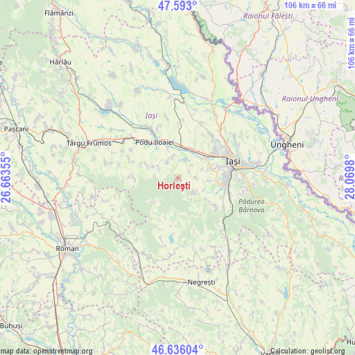
Horleşti GPS coordinates[2]
47° 7' 0.012" North, 27° 22' 0.012" East
| Map corner | latitude | longitude |
|---|---|---|
| Upper-left | 47.593°, | 26.66355° |
| Center: | 47.11667°, | 27.36667° |
| Lower-right: | 46.63604°, | 28.0698° |
| Map W x H: | 106.4×106.4 km | = 66.1×66.1mi |
| max Lat: | 48.23793° ⇑18.3% North |
| Horleşti: | 47.11667° |
| min Lat: | ⇓81.7% South 43.65638° |
| min Long | Horleşti | max Long |
| 20.31667° | 27.36667° | 29.65403° |
| W 89.2%⇐ | ⇒10.8% E |
Elevation
Elevation of Horleşti is 115 m = 377 ft, and this is 139.9 m = 459 ft below average elevation for this country.
| Max E: |
1278 m = 4193 ft | 73.6% |
| Avg. | 254.9 m = 836 ft | |
| Horleşti | 115 m = 377 ft | |
Min E: |
-2 m = -7 ft | 26.4% |
See also: Romania elevation on elevation.city.
Geographical zone
Horleşti is located in North temperate zone (between Tropic of Cancer and the Arctic Circle). Distance of this North polar circle is 2162.3 km =1343.6 mi to North.| Distance of | km | miles | from Horleşti |
|---|---|---|---|
| North Pole | 4768.2 | 2962.8 | to North |
| Arctic Circle | 2162.3 | 1343.6 | to North |
| Tropic Cancer | 2633 | 1636.1 | to South |
| Equator | 5238.9 | 3255.3 | to South |


Nearby cities:
15 places around Horleşti: (largest is in red/bold)
• Bogdănești
5.3 km =3.3 mi,  91°
91°
• Cogeasca
5.7 km =3.5 mi,  14°
14°
• Domnița
10.9 km =6.8 mi,  192°
192°
• Doroșcani
8.2 km =5.1 mi,  293°
293°
• Dumeşti
7.5 km =4.7 mi,  350°
350°
• Hoisești
9.4 km =5.8 mi,  340°
340°
• Hărpășești
7.4 km =4.6 mi,  300°
300°
• Leţcani
8.3 km =5.2 mi,  27°
27°
• Mânjești
9.4 km =5.8 mi,  126°
126°
• Popeşti
10.7 km =6.6 mi, 290°
• Păușești
5.5 km =3.4 mi,  326°
326°
• Slobozia
7.5 km =4.7 mi,  151°
151°
• Uricani
10 km =6.2 mi,  65°
65°
• Voineşti
6.7 km =4.2 mi, 145°
• Vorovești
7.8 km =4.8 mi, 70°
Sources, notices
• [Note1] Compared only with cities in Romania existing in our database
• [Src1] Map data: © OpenStreetMap contributors (CC-BY-SA)
• [Src2] Other city data from geonames.org with taken over terms of usage.
• [Src3] Geographical zone / Annual Mean Temperature by Robert A. Rohde @ Wikipedia
