Havârna geodata
Havârna (Botoşani) is a seat of a second-order administrative division; located in Romania in Europe/Bucharest (GMT+3) time zone. With population of 5,088 people, there are 753 cities with bigger population in this country. Compared to other cities in Romania, 99.5% of cities are located further ↓South; 75.5% of cities are located further ←West and 69% of cities have higher elevation than Havârna. Note1


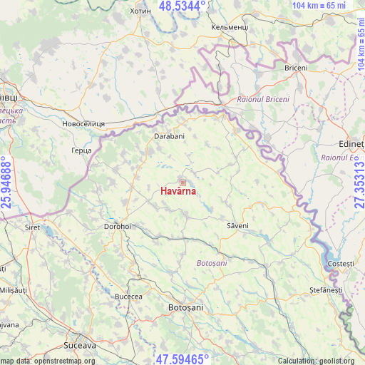
Havârna GPS coordinates[2]
48° 4' 0.012" North, 26° 39' 0" East
| Map corner | latitude | longitude |
|---|---|---|
| Upper-left | 48.5344°, | 25.94688° |
| Center: | 48.06667°, | 26.65° |
| Lower-right: | 47.59465°, | 27.35313° |
| Map W x H: | 104.5×104.5 km | = 64.9×64.9mi |
| max Lat: | 48.23793° ⇑0.5% North |
| Havârna: | 48.06667° |
| min Lat: | ⇓99.5% South 43.65638° |
| min Long | Havârna | max Long |
| 20.31667° | 26.65° | 29.65403° |
| W 75.5%⇐ | ⇒24.5% E |
Elevation
Elevation of Havârna is 131 m = 430 ft, and this is 123.9 m = 406 ft below average elevation for this country.
| Max E: |
1278 m = 4193 ft | 69% |
| Avg. | 254.9 m = 836 ft | |
| Havârna | 131 m = 430 ft | |
Min E: |
-2 m = -7 ft | 31% |
See also: Romania elevation on elevation.city.
Geographical zone
Havârna is located in North temperate zone (between Tropic of Cancer and the Arctic Circle). Distance of this North polar circle is 2056.7 km =1278 mi to North.| Distance of | km | miles | from Havârna |
|---|---|---|---|
| North Pole | 4662.5 | 2897.1 | to North |
| Arctic Circle | 2056.7 | 1278 | to North |
| Tropic Cancer | 2738.6 | 1701.7 | to South |
| Equator | 5344.5 | 3320.9 | to South |


Nearby cities:
15 places around Havârna: (largest is in red/bold)
• Arborea
9.8 km =6.1 mi,  260°
260°
• Codreni
10.5 km =6.5 mi,  73°
73°
• Conceşti
13.4 km =8.3 mi,  326°
326°
• Cordăreni
10.5 km =6.5 mi,  208°
208°
• Drăguşeni
13.6 km =8.5 mi,  114°
114°
• Dumeni
10.3 km =6.4 mi,  230°
230°
• George Enescu
12.9 km =8 mi,  253°
253°
• Lișmănița
8.1 km =5 mi,  3°
3°
• Lișna
13.6 km =8.5 mi,  289°
289°
• Mileanca
4.2 km =2.6 mi,  63°
63°
• Negreni
11.1 km =6.9 mi,  132°
132°
• Smârdan
13.5 km =8.4 mi,  275°
275°
• Tătărășeni
2.6 km =1.6 mi,  96°
96°
• Viişoara
12.7 km =7.9 mi,  29°
29°
• Vorniceni
9.3 km =5.8 mi,  172°
172°
Sources, notices
• [Note1] Compared only with cities in Romania existing in our database
• [Src1] Map data: © OpenStreetMap contributors (CC-BY-SA)
• [Src2] Other city data from geonames.org with taken over terms of usage.
• [Src3] Geographical zone / Annual Mean Temperature by Robert A. Rohde @ Wikipedia
