Griviţa geodata
Griviţa (Galaţi) is a seat of a second-order administrative division; located in Romania in Europe/Bucharest (GMT+3) time zone. With population of 3,694 people, there are 1327 cities with bigger population in this country. Compared to other cities in Romania, 51.7% of cities are located further ↑North; 92.7% of cities are located further ←West and 85.7% of cities have higher elevation than Griviţa. Note1


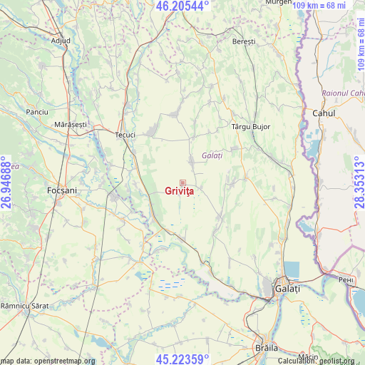
Griviţa GPS coordinates[2]
45° 43' 0.012" North, 27° 39' 0" East
| Map corner | latitude | longitude |
|---|---|---|
| Upper-left | 46.20544°, | 26.94688° |
| Center: | 45.71667°, | 27.65° |
| Lower-right: | 45.22359°, | 28.35313° |
| Map W x H: | 109.2×109.2 km | = 67.9×67.9mi |
| max Lat: | 48.23793° ⇑51.7% North |
| Griviţa: | 45.71667° |
| min Lat: | ⇓48.3% South 43.65638° |
| min Long | Griviţa | max Long |
| 20.31667° | 27.65° | 29.65403° |
| W 92.7%⇐ | ⇒7.3% E |
Elevation
Elevation of Griviţa is 76 m = 249 ft, and this is 178.9 m = 587 ft below average elevation for this country.
| Max E: |
1278 m = 4193 ft | 85.7% |
| Avg. | 254.9 m = 836 ft | |
| Griviţa | 76 m = 249 ft | |
Min E: |
-2 m = -7 ft | 14.3% |
See also: Romania elevation on elevation.city.
Geographical zone
Griviţa is located in North temperate zone (between Tropic of Cancer and the Arctic Circle). Distance of this North polar circle is 2318 km =1440.3 mi to North.| Distance of | km | miles | from Griviţa |
|---|---|---|---|
| North Pole | 4923.8 | 3059.5 | to North |
| Arctic Circle | 2318 | 1440.3 | to North |
| Tropic Cancer | 2477.3 | 1539.3 | to South |
| Equator | 5083.2 | 3158.6 | to South |


Nearby cities:
15 places around Griviţa: (largest is in red/bold)
• Barcea
14.7 km =9.1 mi,  284°
284°
• Bucești
11.7 km =7.3 mi,  232°
232°
• Costache Negri
5.5 km =3.4 mi,  109°
109°
• Cudalbi
8.4 km =5.2 mi,  27°
27°
• Călmățui
3.8 km =2.4 mi,  196°
196°
• Hanu Conachi
15.1 km =9.4 mi, 196°
• Iveşti
11 km =6.8 mi,  250°
250°
• Lieşti
15.2 km =9.4 mi,  222°
222°
• Pechea
14.9 km =9.3 mi,  128°
128°
• Rediu
14.2 km =8.8 mi,  90°
90°
• Suhurlui
13.8 km =8.6 mi,  84°
84°
• Torcești
12.9 km =8 mi,  260°
260°
• Umbrăreşti
14.2 km =8.8 mi,  270°
270°
• Umbrărești-Deal
14.4 km =8.9 mi, 262°
• Valea Mărului
13.9 km =8.6 mi,  13°
13°
Sources, notices
• [Note1] Compared only with cities in Romania existing in our database
• [Src1] Map data: © OpenStreetMap contributors (CC-BY-SA)
• [Src2] Other city data from geonames.org with taken over terms of usage.
• [Src3] Geographical zone / Annual Mean Temperature by Robert A. Rohde @ Wikipedia
