Gorbăneşti geodata
Gorbăneşti (Botoşani) is a seat of a second-order administrative division; located in Romania in Europe/Bucharest (GMT+3) time zone. With population of 3,587 people, there are 1383 cities with bigger population in this country. Compared to other cities in Romania, 96.3% of cities are located further ↓South; 79.7% of cities are located further ←West and 50.3% of cities have lower elevation than Gorbăneşti. Note1


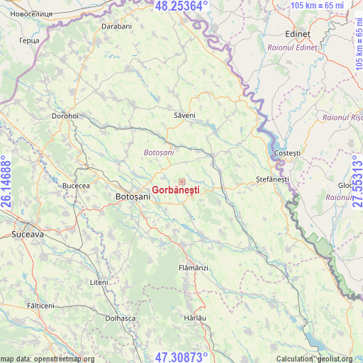
Gorbăneşti GPS coordinates[2]
47° 46' 59.988" North, 26° 51' 0" East
| Map corner | latitude | longitude |
|---|---|---|
| Upper-left | 48.25364°, | 26.14688° |
| Center: | 47.78333°, | 26.85° |
| Lower-right: | 47.30873°, | 27.55313° |
| Map W x H: | 105.1×105.1 km | = 65.3×65.3mi |
| max Lat: | 48.23793° ⇑3.7% North |
| Gorbăneşti: | 47.78333° |
| min Lat: | ⇓96.3% South 43.65638° |
| min Long | Gorbăneşti | max Long |
| 20.31667° | 26.85° | 29.65403° |
| W 79.7%⇐ | ⇒20.3% E |
Elevation
Elevation of Gorbăneşti is 213 m = 699 ft, and this is 41.9 m = 137 ft below average elevation for this country.
| Max E: |
1278 m = 4193 ft | 49.7% |
| Avg. | 254.9 m = 836 ft | |
| Gorbăneşti | 213 m = 699 ft | |
Min E: |
-2 m = -7 ft | 50.3% |
See also: Romania elevation on elevation.city.
Geographical zone
Gorbăneşti is located in North temperate zone (between Tropic of Cancer and the Arctic Circle). Distance of this North polar circle is 2088.2 km =1297.5 mi to North.| Distance of | km | miles | from Gorbăneşti |
|---|---|---|---|
| North Pole | 4694.1 | 2916.8 | to North |
| Arctic Circle | 2088.2 | 1297.5 | to North |
| Tropic Cancer | 2707.1 | 1682.1 | to South |
| Equator | 5313 | 3301.3 | to South |


Nearby cities:
15 places around Gorbăneşti: (largest is in red/bold)
• Blândeşti
9.3 km =5.8 mi,  172°
172°
• Burlești
3.3 km =2.1 mi,  210°
210°
• Cerchejeni
10.4 km =6.5 mi, 166°
• Drislea
9.3 km =5.8 mi,  98°
98°
• Hulub
9.8 km =6.1 mi,  61°
61°
• Iacobeni
9.8 km =6.1 mi,  28°
28°
• Mânăstireni
8.4 km =5.2 mi,  309°
309°
• Roșiori
9.9 km =6.2 mi,  255°
255°
• Socrujeni
4.6 km =2.9 mi,  90°
90°
• Stăuceni
10.5 km =6.5 mi,  225°
225°
• Tocileni
9.3 km =5.8 mi, 210°
• Unţeni
5.3 km =3.3 mi,  290°
290°
• Vicoleni
10.7 km =6.6 mi,  359°
359°
• Vânători
3.8 km =2.4 mi,  157°
157°
• Șoldănești
7.8 km =4.8 mi,  133°
133°
Sources, notices
• [Note1] Compared only with cities in Romania existing in our database
• [Src1] Map data: © OpenStreetMap contributors (CC-BY-SA)
• [Src2] Other city data from geonames.org with taken over terms of usage.
• [Src3] Geographical zone / Annual Mean Temperature by Robert A. Rohde @ Wikipedia
