Gighera geodata
Gighera (Dolj) is a seat of a second-order administrative division; located in Romania in Europe/Bucharest (GMT+3) time zone. With population of 3,609 people, there are 1371 cities with bigger population in this country. Compared to other cities in Romania, 99% of cities are located further ↑North; 72.6% of cities are located further →East and 94.7% of cities have higher elevation than Gighera. Note1


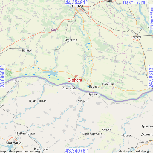
Gighera GPS coordinates[2]
43° 51' 0" North, 23° 48' 0" East
| Map corner | latitude | longitude |
|---|---|---|
| Upper-left | 44.35491°, | 23.09688° |
| Center: | 43.85°, | 23.8° |
| Lower-right: | 43.34078°, | 24.50313° |
| Map W x H: | 112.8×112.8 km | = 70.1×70.1mi |
| max Lat: | 48.23793° ⇑99% North |
| Gighera: | 43.85° |
| min Lat: | ⇓1% South 43.65638° |
| min Long | Gighera | max Long |
| 20.31667° | 23.8° | 29.65403° |
| W 27.4%⇐ | ⇒72.6% E |
Elevation
Elevation of Gighera is 36 m = 118 ft, and this is 218.9 m = 718 ft below average elevation for this country.
| Max E: |
1278 m = 4193 ft | 94.7% |
| Avg. | 254.9 m = 836 ft | |
| Gighera | 36 m = 118 ft | |
Min E: |
-2 m = -7 ft | 5.3% |
See also: Romania elevation on elevation.city.
Geographical zone
Gighera is located in North temperate zone (between Tropic of Cancer and the Arctic Circle). Distance of this Northern Tropic circle is 2269.7 km =1410.3 mi to South.| Distance of | km | miles | from Gighera |
|---|---|---|---|
| North Pole | 5131.4 | 3188.5 | to North |
| Arctic Circle | 2525.5 | 1569.3 | to North |
| Tropic Cancer | 2269.7 | 1410.3 | to South |
| Equator | 4875.7 | 3029.6 | to South |


Nearby cities:
15 places around Gighera: (largest is in red/bold)
• Bechet
14.7 km =9.1 mi,  121°
121°
• Comoșteni
5.8 km =3.6 mi,  62°
62°
• Cârna
16.4 km =10.2 mi,  284°
284°
• Căciulătești
15.5 km =9.6 mi,  50°
50°
• Goicea
16.5 km =10.3 mi,  296°
296°
• Gângiova
6.9 km =4.3 mi,  35°
35°
• Lișteava
9.8 km =6.1 mi,  100°
100°
• Măceşu de Jos
7.6 km =4.7 mi, 299°
• Măceşu de Sus
10.9 km =6.8 mi,  312°
312°
• Nedeia
1.9 km =1.2 mi,  269°
269°
• Ostroveni
9.8 km =6.1 mi, 124°
• Piscu Sadovei
11.4 km =7.1 mi,  74°
74°
• Sadova
13.2 km =8.2 mi, 65°
• Valea Stanciului
15.8 km =9.8 mi,  19°
19°
• Zăval
3.4 km =2.1 mi, 95°
Sources, notices
• [Note1] Compared only with cities in Romania existing in our database
• [Src1] Map data: © OpenStreetMap contributors (CC-BY-SA)
• [Src2] Other city data from geonames.org with taken over terms of usage.
• [Src3] Geographical zone / Annual Mean Temperature by Robert A. Rohde @ Wikipedia
