Giarmata geodata
Giarmata (Timiş) is a seat of a second-order administrative division; located in Romania in Europe/Bucharest (GMT+3) time zone. With population of 5,357 people, there are 672 cities with bigger population in this country. Compared to other cities in Romania, 51.3% of cities are located further ↓South; 98.3% of cities are located further →East and 75.1% of cities have higher elevation than Giarmata. Note1


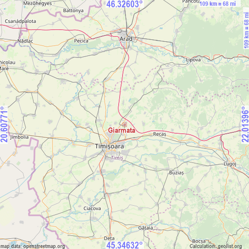
Giarmata GPS coordinates[2]
45° 50' 17.988" North, 21° 18' 38.988" East
| Map corner | latitude | longitude |
|---|---|---|
| Upper-left | 46.32603°, | 20.60771° |
| Center: | 45.83833°, | 21.31083° |
| Lower-right: | 45.34632°, | 22.01396° |
| Map W x H: | 108.9×108.9 km | = 67.7×67.7mi |
| max Lat: | 48.23793° ⇑48.7% North |
| Giarmata: | 45.83833° |
| min Lat: | ⇓51.3% South 43.65638° |
| min Long | Giarmata | max Long |
| 20.31667° | 21.31083° | 29.65403° |
| W 1.7%⇐ | ⇒98.3% E |
Elevation
Elevation of Giarmata is 110 m = 361 ft, and this is 144.9 m = 475 ft below average elevation for this country.
| Max E: |
1278 m = 4193 ft | 75.1% |
| Avg. | 254.9 m = 836 ft | |
| Giarmata | 110 m = 361 ft | |
Min E: |
-2 m = -7 ft | 24.9% |
See also: Romania elevation on elevation.city.
Geographical zone
Giarmata is located in North temperate zone (between Tropic of Cancer and the Arctic Circle). Distance of this North polar circle is 2304.4 km =1431.9 mi to North.| Distance of | km | miles | from Giarmata |
|---|---|---|---|
| North Pole | 4910.3 | 3051.1 | to North |
| Arctic Circle | 2304.4 | 1431.9 | to North |
| Tropic Cancer | 2490.8 | 1547.7 | to South |
| Equator | 5096.7 | 3166.9 | to South |


Nearby cities:
15 places around Giarmata: (largest is in red/bold)
• Bencecu de Sus
10.4 km =6.5 mi,  60°
60°
• Bucovăț
10.8 km =6.7 mi,  148°
148°
• Cornești
10.5 km =6.5 mi,  321°
321°
• Covaci
6.1 km =3.8 mi,  265°
265°
• Dumbrăviţa
7 km =4.3 mi,  229°
229°
• Ghiroda
8.3 km =5.2 mi,  185°
185°
• Giarmata-Vii
4.4 km =2.7 mi, 190°
• Ianova
8.5 km =5.3 mi,  89°
89°
• Izvin
12.4 km =7.7 mi,  109°
109°
• Moșnița Veche
11.6 km =7.2 mi,  171°
171°
• Murani
9.6 km =6 mi,  357°
357°
• Pişchia
7.5 km =4.7 mi,  15°
15°
• Remetea Mare
8.3 km =5.2 mi,  142°
142°
• Sânandrei
11.2 km =7 mi,  278°
278°
• Timişoara
11.5 km =7.1 mi,  215°
215°
Sources, notices
• [Note1] Compared only with cities in Romania existing in our database
• [Src1] Map data: © OpenStreetMap contributors (CC-BY-SA)
• [Src2] Other city data from geonames.org with taken over terms of usage.
• [Src3] Geographical zone / Annual Mean Temperature by Robert A. Rohde @ Wikipedia
