Ghigoiești geodata
Ghigoiești (Neamţ) is a populated place; located in Romania in Europe/Bucharest (GMT+3) time zone. With population of 649 people, there are 5889 cities with bigger population in this country. Compared to other cities in Romania, 78.5% of cities are located further ↓South; 74.1% of cities are located further ←West and 75.9% of cities have lower elevation than Ghigoiești. Note1


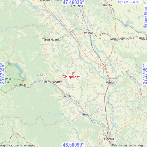
Ghigoiești GPS coordinates[2]
46° 58' 58.188" North, 26° 34' 36.048" East
| Map corner | latitude | longitude |
|---|---|---|
| Upper-left | 47.46036°, | 25.87356° |
| Center: | 46.98283°, | 26.57668° |
| Lower-right: | 46.50099°, | 27.27981° |
| Map W x H: | 106.7×106.7 km | = 66.3×66.3mi |
| max Lat: | 48.23793° ⇑21.5% North |
| Ghigoiești: | 46.98283° |
| min Lat: | ⇓78.5% South 43.65638° |
| min Long | Ghigoiești | max Long |
| 20.31667° | 26.57668° | 29.65403° |
| W 74.1%⇐ | ⇒25.9% E |
Elevation
Elevation of Ghigoiești is 360 m = 1181 ft, and this is 105.1 m = 345 ft above average elevation for this country.
| Max E: |
1278 m = 4193 ft | 24.1% |
| Ghigoiești | 360 m 1181 ft | |
| Avg. | 254.9 m = 836 ft | |
Min E: |
-2 m = -7 ft | 75.9% |
See also: Romania elevation on elevation.city.
Geographical zone
Ghigoiești is located in North temperate zone (between Tropic of Cancer and the Arctic Circle). Distance of this North polar circle is 2177.2 km =1352.8 mi to North.| Distance of | km | miles | from Ghigoiești |
|---|---|---|---|
| North Pole | 4783.1 | 2972.1 | to North |
| Arctic Circle | 2177.2 | 1352.8 | to North |
| Tropic Cancer | 2618.1 | 1626.8 | to South |
| Equator | 5224 | 3246 | to South |


Nearby cities:
15 places around Ghigoiești: (largest is in red/bold)
• Boțești
7.7 km =4.8 mi,  227°
227°
• Bârgăuani
4.3 km =2.7 mi,  89°
89°
• Bălănești
6 km =3.7 mi,  129°
129°
• Căciulești
7.8 km =4.8 mi,  254°
254°
• Dochia
8.4 km =5.2 mi,  184°
184°
• Dragomireşti
5 km =3.1 mi,  318°
318°
• Girov
5.8 km =3.6 mi, 231°
• Gura Văii
10 km =6.2 mi, 253°
• Hlăpești
6.4 km =4 mi,  14°
14°
• Mărgineni
10.2 km =6.3 mi,  154°
154°
• Ruginoasa
9.8 km =6.1 mi, 87°
• Războienii de Jos
9.6 km =6 mi,  354°
354°
• Vad
5.1 km =3.2 mi,  338°
338°
• Văleni
10 km =6.2 mi,  57°
57°
• Ştefan cel Mare
5 km =3.1 mi,  272°
272°
Sources, notices
• [Note1] Compared only with cities in Romania existing in our database
• [Src1] Map data: © OpenStreetMap contributors (CC-BY-SA)
• [Src2] Other city data from geonames.org with taken over terms of usage.
• [Src3] Geographical zone / Annual Mean Temperature by Robert A. Rohde @ Wikipedia
