Gălbinași geodata
Gălbinași (Călăraşi) is a seat of a second-order administrative division; located in Romania in Europe/Bucharest (GMT+3) time zone. With population of 3,180 people, there are 1631 cities with bigger population in this country. Compared to other cities in Romania, 90.3% of cities are located further ↑North; 71.2% of cities are located further ←West and 92.9% of cities have higher elevation than Gălbinași. Note1


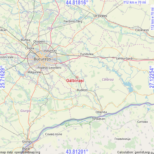
Gălbinași GPS coordinates[2]
44° 19' 2.064" North, 26° 25' 9.876" East
| Map corner | latitude | longitude |
|---|---|---|
| Upper-left | 44.81816°, | 25.71629° |
| Center: | 44.31724°, | 26.41941° |
| Lower-right: | 43.81201°, | 27.12254° |
| Map W x H: | 111.9×111.9 km | = 69.5×69.5mi |
| max Lat: | 48.23793° ⇑90.3% North |
| Gălbinași: | 44.31724° |
| min Lat: | ⇓9.7% South 43.65638° |
| min Long | Gălbinași | max Long |
| 20.31667° | 26.41941° | 29.65403° |
| W 71.2%⇐ | ⇒28.8% E |
Elevation
Elevation of Gălbinași is 44 m = 144 ft, and this is 210.9 m = 692 ft below average elevation for this country.
| Max E: |
1278 m = 4193 ft | 92.9% |
| Avg. | 254.9 m = 836 ft | |
| Gălbinași | 44 m = 144 ft | |
Min E: |
-2 m = -7 ft | 7.1% |
See also: Romania elevation on elevation.city.
Geographical zone
Gălbinași is located in North temperate zone (between Tropic of Cancer and the Arctic Circle). Distance of this Northern Tropic circle is 2321.7 km =1442.6 mi to South.| Distance of | km | miles | from Gălbinași |
|---|---|---|---|
| North Pole | 5079.4 | 3156.2 | to North |
| Arctic Circle | 2473.6 | 1537 | to North |
| Tropic Cancer | 2321.7 | 1442.6 | to South |
| Equator | 4927.6 | 3061.9 | to South |


Nearby cities:
15 places around Gălbinași: (largest is in red/bold)
• Aprozi
8.7 km =5.4 mi,  130°
130°
• Buciumeni
7 km =4.3 mi,  181°
181°
• Budeşti
9.9 km =6.2 mi,  158°
158°
• Cucuieți
2.5 km =1.6 mi,  307°
307°
• Dorobanțu
4.6 km =2.9 mi,  333°
333°
• Frumuşani
7.8 km =4.8 mi,  252°
252°
• Fundeni
9.2 km =5.7 mi,  323°
323°
• Gruiu
9.4 km =5.8 mi, 180°
• Pasărea
8 km =5 mi,  242°
242°
• Plătăreşti
5.6 km =3.5 mi, 310°
• Podu Pitarului
4.1 km =2.5 mi, 308°
• Progresu
5.7 km =3.5 mi,  35°
35°
• Pădurișu
9.1 km =5.7 mi,  269°
269°
• Sohatu
6.4 km =4 mi,  90°
90°
• Vasilaţi
4 km =2.5 mi,  145°
145°
Sources, notices
• [Note1] Compared only with cities in Romania existing in our database
• [Src1] Map data: © OpenStreetMap contributors (CC-BY-SA)
• [Src2] Other city data from geonames.org with taken over terms of usage.
• [Src3] Geographical zone / Annual Mean Temperature by Robert A. Rohde @ Wikipedia
