Găgeşti geodata
Găgeşti (Vaslui) is a seat of a second-order administrative division; located in Romania in Europe/Bucharest (GMT+3) time zone. With population of 2,252 people, there are 2368 cities with bigger population in this country. Compared to other cities in Romania, 62.9% of cities are located further ↓South; 96% of cities are located further ←West and 79.9% of cities have higher elevation than Găgeşti. Note1


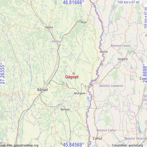
Găgeşti GPS coordinates[2]
46° 19' 59.988" North, 27° 58' 0.012" East
| Map corner | latitude | longitude |
|---|---|---|
| Upper-left | 46.81666°, | 27.26355° |
| Center: | 46.33333°, | 27.96667° |
| Lower-right: | 45.84569°, | 28.6698° |
| Map W x H: | 108×108 km | = 67.1×67.1mi |
| max Lat: | 48.23793° ⇑37.1% North |
| Găgeşti: | 46.33333° |
| min Lat: | ⇓62.9% South 43.65638° |
| min Long | Găgeşti | max Long |
| 20.31667° | 27.96667° | 29.65403° |
| W 96%⇐ | ⇒4% E |
Elevation
Elevation of Găgeşti is 95 m = 312 ft, and this is 159.9 m = 525 ft below average elevation for this country.
| Max E: |
1278 m = 4193 ft | 79.9% |
| Avg. | 254.9 m = 836 ft | |
| Găgeşti | 95 m = 312 ft | |
Min E: |
-2 m = -7 ft | 20.1% |
See also: Romania elevation on elevation.city.
Geographical zone
Găgeşti is located in North temperate zone (between Tropic of Cancer and the Arctic Circle). Distance of this North polar circle is 2249.4 km =1397.7 mi to North.| Distance of | km | miles | from Găgeşti |
|---|---|---|---|
| North Pole | 4855.3 | 3016.9 | to North |
| Arctic Circle | 2249.4 | 1397.7 | to North |
| Tropic Cancer | 2545.9 | 1581.9 | to South |
| Equator | 5151.8 | 3201.2 | to South |


Nearby cities:
15 places around Găgeşti: (largest is in red/bold)
• Bozia
12 km =7.5 mi,  86°
86°
• Copăceana
7.8 km =4.8 mi,  71°
71°
• Dodești
6.1 km =3.8 mi,  292°
292°
• Epureni
10.5 km =6.5 mi,  203°
203°
• Fedești
7.5 km =4.7 mi,  245°
245°
• Floreni
10.8 km =6.7 mi,  177°
177°
• Ghermănești
9.8 km =6.1 mi,  263°
263°
• Giurcani
5.7 km =3.5 mi,  168°
168°
• Gura Idrici
11 km =6.8 mi,  324°
324°
• Peicani
3.5 km =2.2 mi,  151°
151°
• Raiu
11.1 km =6.9 mi,  159°
159°
• Roşieşti
12.8 km =8 mi,  330°
330°
• Stoișești
8.7 km =5.4 mi,  276°
276°
• Viişoara
8.5 km =5.3 mi,  311°
311°
• Şuletea
7.6 km =4.7 mi,  222°
222°
Sources, notices
• [Note1] Compared only with cities in Romania existing in our database
• [Src1] Map data: © OpenStreetMap contributors (CC-BY-SA)
• [Src2] Other city data from geonames.org with taken over terms of usage.
• [Src3] Geographical zone / Annual Mean Temperature by Robert A. Rohde @ Wikipedia
