Frecăţei geodata
Frecăţei (Brăila) is a seat of a second-order administrative division; located in Romania in Europe/Bucharest (GMT+3) time zone. With population of 1,494 people, there are 3188 cities with bigger population in this country. Compared to other cities in Romania, 73.2% of cities are located further ↑North; 97.3% of cities are located further ←West and 99.8% of cities have higher elevation than Frecăţei. Note1


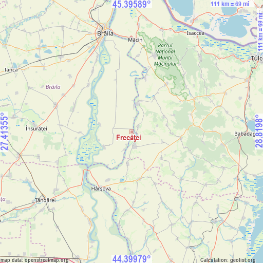
Frecăţei GPS coordinates[2]
44° 54' 0" North, 28° 7' 0.012" East
| Map corner | latitude | longitude |
|---|---|---|
| Upper-left | 45.39589°, | 27.41355° |
| Center: | 44.9°, | 28.11667° |
| Lower-right: | 44.39979°, | 28.8198° |
| Map W x H: | 110.8×110.8 km | = 68.8×68.8mi |
| max Lat: | 48.23793° ⇑73.2% North |
| Frecăţei: | 44.9° |
| min Lat: | ⇓26.8% South 43.65638° |
| min Long | Frecăţei | max Long |
| 20.31667° | 28.11667° | 29.65403° |
| W 97.3%⇐ | ⇒2.7% E |
Elevation
Elevation of Frecăţei is 3 m = 10 ft, and this is 251.9 m = 826 ft below average elevation for this country.
| Max E: |
1278 m = 4193 ft | 99.8% |
| Avg. | 254.9 m = 836 ft | |
| Frecăţei | 3 m = 10 ft | |
Min E: |
-2 m = -7 ft | 0.2% |
See also: Romania elevation on elevation.city.
Geographical zone
Frecăţei is located in North temperate zone (between Tropic of Cancer and the Arctic Circle). Distance of this Northern Tropic circle is 2386.5 km =1482.9 mi to South.| Distance of | km | miles | from Frecăţei |
|---|---|---|---|
| North Pole | 5014.6 | 3115.9 | to North |
| Arctic Circle | 2408.8 | 1496.8 | to North |
| Tropic Cancer | 2386.5 | 1482.9 | to South |
| Equator | 4992.4 | 3102.1 | to South |


Nearby cities:
15 places around Frecăţei: (largest is in red/bold)
• Agaua
8 km =5 mi,  203°
203°
• Băndoiu
14.4 km =8.9 mi,  254°
254°
• Cârjelari
19 km =11.8 mi,  68°
68°
• Dorobanţu
13.1 km =8.1 mi,  64°
64°
• Dăeni
7.4 km =4.6 mi,  180°
180°
• Făgărașu Nou
13.8 km =8.6 mi,  110°
110°
• Gârliciu
15.1 km =9.4 mi,  190°
190°
• Măgureni
19.9 km =12.4 mi,  229°
229°
• Măraşu
13.1 km =8.1 mi,  244°
244°
• Ostrov
4.5 km =2.8 mi,  35°
35°
• Peceneaga
13 km =8.1 mi,  5°
5°
• Titcov
10.8 km =6.7 mi,  3°
3°
• Topolog
19.8 km =12.3 mi,  95°
95°
• Traian
17.1 km =10.6 mi,  33°
33°
• Țăcău
13.7 km =8.5 mi,  283°
283°
Sources, notices
• [Note1] Compared only with cities in Romania existing in our database
• [Src1] Map data: © OpenStreetMap contributors (CC-BY-SA)
• [Src2] Other city data from geonames.org with taken over terms of usage.
• [Src3] Geographical zone / Annual Mean Temperature by Robert A. Rohde @ Wikipedia
