Frăsinet geodata
Frăsinet (Prahova) is a section of populated place; located in Romania in Europe/Bucharest (GMT+3) time zone. With population of 544 people, there are 6641 cities with bigger population in this country. Compared to other cities in Romania, 61.8% of cities are located further ↑North; 57.2% of cities are located further ←West and 91.3% of cities have lower elevation than Frăsinet. Note1


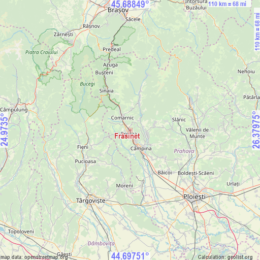
Frăsinet GPS coordinates[2]
45° 11' 42.576" North, 25° 40' 35.832" East
| Map corner | latitude | longitude |
|---|---|---|
| Upper-left | 45.68849°, | 24.9735° |
| Center: | 45.19516°, | 25.67662° |
| Lower-right: | 44.69751°, | 26.37975° |
| Map W x H: | 110.2×110.2 km | = 68.5×68.5mi |
| max Lat: | 48.23793° ⇑61.8% North |
| Frăsinet: | 45.19516° |
| min Lat: | ⇓38.2% South 43.65638° |
| min Long | Frăsinet | max Long |
| 20.31667° | 25.67662° | 29.65403° |
| W 57.2%⇐ | ⇒42.8% E |
Elevation
Elevation of Frăsinet is 534 m = 1752 ft, and this is 279.1 m = 916 ft above average elevation for this country.
| Max E: |
1278 m = 4193 ft | 8.7% |
| Frăsinet | 534 m 1752 ft | |
| Avg. | 254.9 m = 836 ft | |
Min E: |
-2 m = -7 ft | 91.3% |
See also: Romania elevation on elevation.city.
Geographical zone
Frăsinet is located in North temperate zone (between Tropic of Cancer and the Arctic Circle). Distance of this North polar circle is 2375.9 km =1476.3 mi to North.| Distance of | km | miles | from Frăsinet |
|---|---|---|---|
| North Pole | 4981.8 | 3095.5 | to North |
| Arctic Circle | 2375.9 | 1476.3 | to North |
| Tropic Cancer | 2419.3 | 1503.3 | to South |
| Equator | 5025.2 | 3122.5 | to South |


Nearby cities:
15 places around Frăsinet: (largest is in red/bold)
• Breaza
1.5 km =0.9 mi,  210°
210°
• Breaza de Jos
2.7 km =1.7 mi,  181°
181°
• Breaza de Sus
1.7 km =1.1 mi,  283°
283°
• Cornu de Jos
4.8 km =3 mi,  152°
152°
• Cornu de Sus
3.7 km =2.3 mi, 149°
• Gura Beliei
2.7 km =1.7 mi,  308°
308°
• Lunca Mare
5.4 km =3.4 mi,  85°
85°
• Nistorești
1 km =0.6 mi,  318°
318°
• Plaiu Câmpinei
4.6 km =2.9 mi,  106°
106°
• Podu Lung
5 km =3.1 mi,  332°
332°
• Poiana
5.7 km =3.5 mi,  349°
349°
• Surdești
4.1 km =2.5 mi,  260°
260°
• Valea Târsei
3.9 km =2.4 mi,  239°
239°
• Vistieru
3.7 km =2.3 mi,  32°
32°
• Şotrile
3.9 km =2.4 mi,  52°
52°
Sources, notices
• [Note1] Compared only with cities in Romania existing in our database
• [Src1] Map data: © OpenStreetMap contributors (CC-BY-SA)
• [Src2] Other city data from geonames.org with taken over terms of usage.
• [Src3] Geographical zone / Annual Mean Temperature by Robert A. Rohde @ Wikipedia
