Fântânele geodata
Fântânele (Suceava) is a seat of a second-order administrative division; located in Romania in Europe/Bucharest (GMT+3) time zone. With population of 1,100 people, there are 3991 cities with bigger population in this country. Compared to other cities in Romania, 92.6% of cities are located further ↓South; 73.2% of cities are located further ←West and 55.4% of cities have lower elevation than Fântânele. Note1


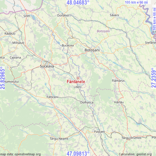
Fântânele GPS coordinates[2]
47° 34' 28.668" North, 26° 31' 57.972" East
| Map corner | latitude | longitude |
|---|---|---|
| Upper-left | 48.04683°, | 25.82965° |
| Center: | 47.57463°, | 26.53277° |
| Lower-right: | 47.09813°, | 27.2359° |
| Map W x H: | 105.5×105.5 km | = 65.6×65.6mi |
| max Lat: | 48.23793° ⇑7.4% North |
| Fântânele: | 47.57463° |
| min Lat: | ⇓92.6% South 43.65638° |
| min Long | Fântânele | max Long |
| 20.31667° | 26.53277° | 29.65403° |
| W 73.2%⇐ | ⇒26.8% E |
Elevation
Elevation of Fântânele is 240 m = 787 ft, and this is 14.9 m = 49 ft below average elevation for this country.
| Max E: |
1278 m = 4193 ft | 44.6% |
| Avg. | 254.9 m = 836 ft | |
| Fântânele | 240 m = 787 ft | |
Min E: |
-2 m = -7 ft | 55.4% |
See also: Romania elevation on elevation.city.
Geographical zone
Fântânele is located in North temperate zone (between Tropic of Cancer and the Arctic Circle). Distance of this North polar circle is 2111.4 km =1312 mi to North.| Distance of | km | miles | from Fântânele |
|---|---|---|---|
| North Pole | 4717.3 | 2931.2 | to North |
| Arctic Circle | 2111.4 | 1312 | to North |
| Tropic Cancer | 2683.9 | 1667.7 | to South |
| Equator | 5289.8 | 3286.9 | to South |


Nearby cities:
15 places around Fântânele: (largest is in red/bold)
• Bănești
1.8 km =1.1 mi,  336°
336°
• Chilișeni
4.2 km =2.6 mi,  251°
251°
• Hancea
6.7 km =4.2 mi,  298°
298°
• Icușeni
5.2 km =3.2 mi,  67°
67°
• Joldești
3.7 km =2.3 mi,  116°
116°
• Liteni
6 km =3.7 mi,  183°
183°
• Poiana
6.4 km =4 mi,  62°
62°
• Roșcani
4.7 km =2.9 mi,  165°
165°
• Sarafinești
7.3 km =4.5 mi,  49°
49°
• Siliștea
7.1 km =4.4 mi,  214°
214°
• Stamate
3.7 km =2.3 mi, 341°
• Vorona
7.4 km =4.6 mi,  87°
87°
• Vorona Mare
6.6 km =4.1 mi,  108°
108°
• Vorona Teodoru
5.7 km =3.5 mi, 118°
• Știrbăț
3.7 km =2.3 mi,  234°
234°
Sources, notices
• [Note1] Compared only with cities in Romania existing in our database
• [Src1] Map data: © OpenStreetMap contributors (CC-BY-SA)
• [Src2] Other city data from geonames.org with taken over terms of usage.
• [Src3] Geographical zone / Annual Mean Temperature by Robert A. Rohde @ Wikipedia
