Dumitrești geodata
Dumitrești (Vrancea) is a seat of a second-order administrative division; located in Romania in Europe/Bucharest (GMT+3) time zone. With population of 758 people, there are 5251 cities with bigger population in this country. Compared to other cities in Romania, 54.2% of cities are located further ↑North; 81.7% of cities are located further ←West and 65.4% of cities have lower elevation than Dumitrești. Note1


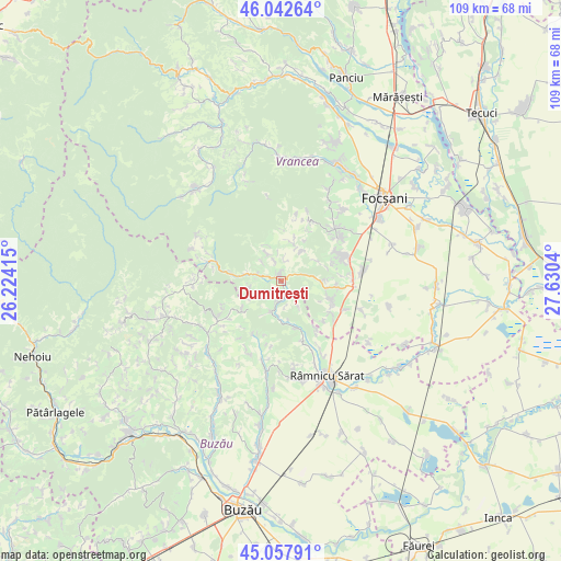
Dumitrești GPS coordinates[2]
45° 33' 8.748" North, 26° 55' 38.172" East
| Map corner | latitude | longitude |
|---|---|---|
| Upper-left | 46.04264°, | 26.22415° |
| Center: | 45.55243°, | 26.92727° |
| Lower-right: | 45.05791°, | 27.6304° |
| Map W x H: | 109.5×109.5 km | = 68×68mi |
| max Lat: | 48.23793° ⇑54.2% North |
| Dumitrești: | 45.55243° |
| min Lat: | ⇓45.8% South 43.65638° |
| min Long | Dumitrești | max Long |
| 20.31667° | 26.92727° | 29.65403° |
| W 81.7%⇐ | ⇒18.3% E |
Elevation
Elevation of Dumitrești is 292 m = 958 ft, and this is 37.1 m = 122 ft above average elevation for this country.
| Max E: |
1278 m = 4193 ft | 34.6% |
| Dumitrești | 292 m 958 ft | |
| Avg. | 254.9 m = 836 ft | |
Min E: |
-2 m = -7 ft | 65.4% |
See also: Romania elevation on elevation.city.
Geographical zone
Dumitrești is located in North temperate zone (between Tropic of Cancer and the Arctic Circle). Distance of this North polar circle is 2336.2 km =1451.6 mi to North.| Distance of | km | miles | from Dumitrești |
|---|---|---|---|
| North Pole | 4942.1 | 3070.9 | to North |
| Arctic Circle | 2336.2 | 1451.6 | to North |
| Tropic Cancer | 2459 | 1528 | to South |
| Equator | 5065 | 3147.2 | to South |


Nearby cities:
15 places around Dumitrești: (largest is in red/bold)
• Alexandru Odobescu
4.2 km =2.6 mi,  195°
195°
• Biceștii de Jos
1.2 km =0.7 mi,  165°
165°
• Biceștii de Sus
0.8 km =0.5 mi,  61°
61°
• Bordeşti
9.6 km =6 mi,  91°
91°
• Bordeștii de Jos
8.8 km =5.5 mi,  99°
99°
• Buda
6.2 km =3.9 mi, 200°
• Chiojdeni
4.7 km =2.9 mi,  266°
266°
• Dedulești
9.7 km =6 mi,  161°
161°
• Gura Caliţei
7.8 km =4.8 mi, 63°
• Găloiești
2.3 km =1.4 mi, 91°
• Luncile
8.8 km =5.5 mi,  275°
275°
• Mucești-Dănulești
3.4 km =2.1 mi,  177°
177°
• Terchești
10.3 km =6.4 mi,  69°
69°
• Toropălești
6.7 km =4.2 mi,  185°
185°
• Valea Salciei
10.2 km =6.3 mi,  232°
232°
Sources, notices
• [Note1] Compared only with cities in Romania existing in our database
• [Src1] Map data: © OpenStreetMap contributors (CC-BY-SA)
• [Src2] Other city data from geonames.org with taken over terms of usage.
• [Src3] Geographical zone / Annual Mean Temperature by Robert A. Rohde @ Wikipedia
