Drăgăneşti geodata
Drăgăneşti (Bihor) is a seat of a second-order administrative division; located in Romania in Europe/Bucharest (GMT+3) time zone. With population of 2,872 people, there are 1860 cities with bigger population in this country. Compared to other cities in Romania, 69.7% of cities are located further ↓South; 90.9% of cities are located further →East and 51.5% of cities have higher elevation than Drăgăneşti. Note1


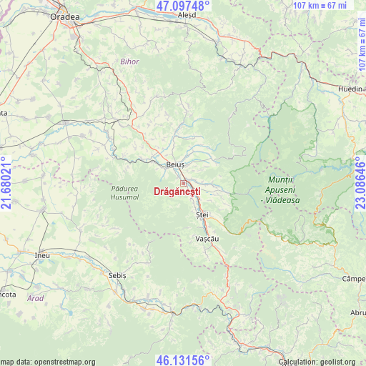
Drăgăneşti GPS coordinates[2]
46° 37' 0.012" North, 22° 22' 59.988" East
| Map corner | latitude | longitude |
|---|---|---|
| Upper-left | 47.09748°, | 21.68021° |
| Center: | 46.61667°, | 22.38333° |
| Lower-right: | 46.13156°, | 23.08646° |
| Map W x H: | 107.4×107.4 km | = 66.7×66.7mi |
| max Lat: | 48.23793° ⇑30.3% North |
| Drăgăneşti: | 46.61667° |
| min Lat: | ⇓69.7% South 43.65638° |
| min Long | Drăgăneşti | max Long |
| 20.31667° | 22.38333° | 29.65403° |
| W 9.1%⇐ | ⇒90.9% E |
Elevation
Elevation of Drăgăneşti is 204 m = 669 ft, and this is 50.9 m = 167 ft below average elevation for this country.
| Max E: |
1278 m = 4193 ft | 51.5% |
| Avg. | 254.9 m = 836 ft | |
| Drăgăneşti | 204 m = 669 ft | |
Min E: |
-2 m = -7 ft | 48.5% |
See also: Romania elevation on elevation.city.
Geographical zone
Drăgăneşti is located in North temperate zone (between Tropic of Cancer and the Arctic Circle). Distance of this North polar circle is 2217.9 km =1378.1 mi to North.| Distance of | km | miles | from Drăgăneşti |
|---|---|---|---|
| North Pole | 4823.8 | 2997.4 | to North |
| Arctic Circle | 2217.9 | 1378.1 | to North |
| Tropic Cancer | 2577.4 | 1601.5 | to South |
| Equator | 5183.3 | 3220.8 | to South |


Nearby cities:
15 places around Drăgăneşti: (largest is in red/bold)
• Beiuş
6.1 km =3.8 mi,  335°
335°
• Bunteşti
6.4 km =4 mi,  90°
90°
• Curăţele
9.6 km =6 mi,  15°
15°
• Finiş
5.4 km =3.4 mi,  289°
289°
• Ghighișeni
8.1 km =5 mi,  153°
153°
• Ioaniș
10.2 km =6.3 mi,  306°
306°
• Lazuri de Beiuş
3.9 km =2.4 mi,  161°
161°
• Lelești
5.6 km =3.5 mi, 86°
• Nimăiești
7.4 km =4.6 mi,  4°
4°
• Petrileni
8.4 km =5.2 mi,  144°
144°
• Poienii de Jos
9 km =5.6 mi,  95°
95°
• Poienii de Sus
10.3 km =6.4 mi, 95°
• Rieni
6.7 km =4.2 mi,  134°
134°
• Tărcaia
2.2 km =1.4 mi,  325°
325°
• Valea de Jos
9.3 km =5.8 mi,  122°
122°
Sources, notices
• [Note1] Compared only with cities in Romania existing in our database
• [Src1] Map data: © OpenStreetMap contributors (CC-BY-SA)
• [Src2] Other city data from geonames.org with taken over terms of usage.
• [Src3] Geographical zone / Annual Mean Temperature by Robert A. Rohde @ Wikipedia
