Coțofenești geodata
Coțofenești (Prahova) is a populated place; located in Romania in Europe/Bucharest (GMT+3) time zone. With population of 955 people, there are 4437 cities with bigger population in this country. Compared to other cities in Romania, 64.2% of cities are located further ↑North; 62.8% of cities are located further ←West and 62.7% of cities have lower elevation than Coțofenești. Note1


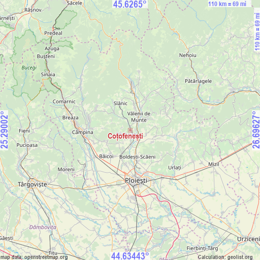
Coțofenești GPS coordinates[2]
45° 7' 57.432" North, 25° 59' 35.304" East
| Map corner | latitude | longitude |
|---|---|---|
| Upper-left | 45.6265°, | 25.29002° |
| Center: | 45.13262°, | 25.99314° |
| Lower-right: | 44.63443°, | 26.69627° |
| Map W x H: | 110.3×110.3 km | = 68.5×68.5mi |
| max Lat: | 48.23793° ⇑64.2% North |
| Coțofenești: | 45.13262° |
| min Lat: | ⇓35.8% South 43.65638° |
| min Long | Coțofenești | max Long |
| 20.31667° | 25.99314° | 29.65403° |
| W 62.8%⇐ | ⇒37.2% E |
Elevation
Elevation of Coțofenești is 278 m = 912 ft, and this is 23.1 m = 76 ft above average elevation for this country.
| Max E: |
1278 m = 4193 ft | 37.3% |
| Coțofenești | 278 m 912 ft | |
| Avg. | 254.9 m = 836 ft | |
Min E: |
-2 m = -7 ft | 62.7% |
See also: Romania elevation on elevation.city.
Geographical zone
Coțofenești is located in North temperate zone (between Tropic of Cancer and the Arctic Circle). Distance of this North polar circle is 2382.9 km =1480.7 mi to North.| Distance of | km | miles | from Coțofenești |
|---|---|---|---|
| North Pole | 4988.8 | 3099.9 | to North |
| Arctic Circle | 2382.9 | 1480.7 | to North |
| Tropic Cancer | 2412.4 | 1499 | to South |
| Equator | 5018.3 | 3118.2 | to South |


Nearby cities:
15 places around Coțofenești: (largest is in red/bold)
• Bughea de Jos
5.7 km =3.5 mi,  22°
22°
• Coada Malului
3.5 km =2.2 mi,  108°
108°
• Cârjari
4.4 km =2.7 mi,  230°
230°
• Dumbrăveşti
5.5 km =3.4 mi,  174°
174°
• Fundeni
3 km =1.9 mi,  126°
126°
• Făgetu
2.2 km =1.4 mi,  77°
77°
• Gornet
6 km =3.7 mi, 107°
• Gura Viţioarei
3.7 km =2.3 mi,  58°
58°
• Iazu
6.1 km =3.8 mi,  159°
159°
• Măgurele
4.8 km =3 mi,  138°
138°
• Mălăeștii de Jos
3.1 km =1.9 mi, 174°
• Trestioara
3.9 km =2.4 mi,  286°
286°
• Vâlcăneşti
5 km =3.1 mi,  249°
249°
• Vălenii de Munte
6.5 km =4 mi,  29°
29°
• Țipărești
6 km =3.7 mi,  208°
208°
Sources, notices
• [Note1] Compared only with cities in Romania existing in our database
• [Src1] Map data: © OpenStreetMap contributors (CC-BY-SA)
• [Src2] Other city data from geonames.org with taken over terms of usage.
• [Src3] Geographical zone / Annual Mean Temperature by Robert A. Rohde @ Wikipedia
