Ciofliceni geodata
Ciofliceni (Ilfov) is a populated place; located in Romania in Europe/Bucharest (GMT+3) time zone. With population of 1,223 people, there are 3694 cities with bigger population in this country. Compared to other cities in Romania, 80.7% of cities are located further ↑North; 65.4% of cities are located further ←West and 80.2% of cities have higher elevation than Ciofliceni. Note1


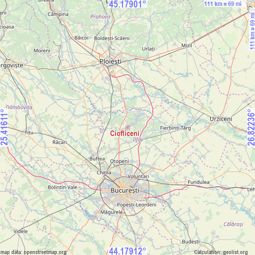
Ciofliceni GPS coordinates[2]
44° 40' 52.392" North, 26° 7' 9.228" East
| Map corner | latitude | longitude |
|---|---|---|
| Upper-left | 45.17901°, | 25.41611° |
| Center: | 44.68122°, | 26.11923° |
| Lower-right: | 44.17912°, | 26.82236° |
| Map W x H: | 111.2×111.2 km | = 69.1×69.1mi |
| max Lat: | 48.23793° ⇑80.7% North |
| Ciofliceni: | 44.68122° |
| min Lat: | ⇓19.3% South 43.65638° |
| min Long | Ciofliceni | max Long |
| 20.31667° | 26.11923° | 29.65403° |
| W 65.4%⇐ | ⇒34.6% E |
Elevation
Elevation of Ciofliceni is 94 m = 308 ft, and this is 160.9 m = 528 ft below average elevation for this country.
| Max E: |
1278 m = 4193 ft | 80.2% |
| Avg. | 254.9 m = 836 ft | |
| Ciofliceni | 94 m = 308 ft | |
Min E: |
-2 m = -7 ft | 19.8% |
See also: Romania elevation on elevation.city.
Geographical zone
Ciofliceni is located in North temperate zone (between Tropic of Cancer and the Arctic Circle). Distance of this Northern Tropic circle is 2362.2 km =1467.8 mi to South.| Distance of | km | miles | from Ciofliceni |
|---|---|---|---|
| North Pole | 5039 | 3131.1 | to North |
| Arctic Circle | 2433.1 | 1511.9 | to North |
| Tropic Cancer | 2362.2 | 1467.8 | to South |
| Equator | 4968.1 | 3087 | to South |


Nearby cities:
15 places around Ciofliceni: (largest is in red/bold)
• Baloteşti
7.2 km =4.5 mi,  181°
181°
• Balta Doamnei
8.5 km =5.3 mi,  26°
26°
• Ciolpani
6.5 km =4 mi,  333°
333°
• Curcubeu
9.3 km =5.8 mi,  12°
12°
• Căciulați
7.3 km =4.5 mi,  144°
144°
• Ghermănești
2.5 km =1.6 mi,  71°
71°
• Izvorani
2 km =1.2 mi,  3°
3°
• Moara Vlăsiei
8.2 km =5.1 mi,  123°
123°
• Periş
8.3 km =5.2 mi,  272°
272°
• Piscu
7 km =4.3 mi, 327°
• Poienarii-Rali
10.2 km =6.3 mi,  318°
318°
• Siliștea Snagovului
8 km =5 mi,  36°
36°
• Snagov
5.5 km =3.4 mi, 67°
• Săftica
7.5 km =4.7 mi,  210°
210°
• Șanțu Florești
9.4 km =5.8 mi,  53°
53°
Sources, notices
• [Note1] Compared only with cities in Romania existing in our database
• [Src1] Map data: © OpenStreetMap contributors (CC-BY-SA)
• [Src2] Other city data from geonames.org with taken over terms of usage.
• [Src3] Geographical zone / Annual Mean Temperature by Robert A. Rohde @ Wikipedia
